Shandong Fengtu IOT Technology Co., Ltd
Sales Manager:Ms. Emily Wang
Cel,Whatsapp,Wechat:+86 15898932201
Email:info@fengtutec.com
Add:No. 155 Optoelectronic Industry Accelerator, Gaoxin District, Weifang, Shandong, China


Sales Manager:Ms. Emily Wang
Cel,Whatsapp,Wechat:+86 15898932201
Email:info@fengtutec.com
Add:No. 155 Optoelectronic Industry Accelerator, Gaoxin District, Weifang, Shandong, China
time:2024-12-26 11:39:21 source:Weather Station viewed:779 time
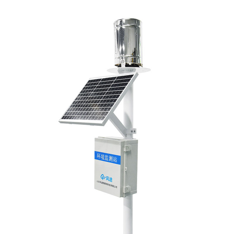
1.Product overview of rain gauge description
rain gauge description Collects and measures the volume or depth of rain that falls at a specific location and is able to measure rainfall over a period of time.rain gauge description is a modern rainfall station based on the Internet of Things.It is composed of a stainless steel rainfall sensor, a collector, a solar power supply system, a pole bracket, etc.The device can send rainfall data in the form of wireless remote transmission, and the data can be sent wirelessly and remotely.Send to the monitoring platform and log in to the Internet of Things Use the online platform to view real-time data and historical records.Rainfall data includes rainfall status, rainfall at each data collection interval, daily rainfall, weekly rainfall, monthly rainfall, annual rainfall, etc.Data sent to the platform can be directly exported to Desktop EXCEL table for users to conduct further data analysis and processing.
Rain gauge description can be widely used in meteorology, flood control, agriculture, hydrology and water conservancy, environmental protection, highways, airports and ports and other fields.It can not only provide original data for relevant departments such as meteorological observatories (stations), hydrological stations, agriculture and forestry, national defense, and field reporting stations to measure parameters such as precipitation amount, precipitation intensity, and precipitation time; it can also provide original data for flood control, water supply dispatching, power stations, and reservoir water regime management.Provide valuable real-time data.
2.rain gauge description product features
Low power collector: static power consumption is less than 50uA
Standard GPRS networking, support for extended Bluetooth and wired transmission
Support modbus485 sensor expansion
Solar Charge Management MPPT Automatic Power Point Tracking
SMS alarm, send SMS to the designated mobile phone after exceeding the limit
Stainless steel material protective box, corrosion-resistant, anti-oxidation, waterproof grade IP66
3.Technical parameters of rain gauge description:
1.Measuring range: Rain intensity 0~4mm/min
2.Measurement accuracy: ±0.2mm
3.Resolution: 0.2mm
4.Reporting form: wireless remote transmission
5.Rain-bearing diameter: φ200mm
6.Power supply method: solar power supply
7.Solar power: 30W
8.Battery parameters: 20Ah
9.Bracket height: 1.5 meters
10.Working environment: -40℃~60℃
4.Introduction to rain gauge description cloud platform
The CS architecture software platform supports direct observation on mobile phones and PC browsers without the need to install additional software.
Support multiple accounts and multiple devices to log in
Supports real-time data display and historical data display dashboard
Cloud servers and cloud data storage are stable, reliable, easy to expand, and load balanced.
Support SMS alarm and threshold setting
Supports map display and viewing device information.
Support data curve analysis
Support data export table format
Supports data forwarding, HJ-212 protocol, TCP forwarding, http protocol, etc.
Support data post-processing function
Supports external running of javascript scripts
An air quality monitoring station is a device system based on the concept of grid - based layout, which conducts all - round and refined monitoring of air quality in a specific area. It divides the monitoring area into multiple grids and sets up monitoring stations at key positions in each grid to a...
The online ammonia nitrogen sensor is a device for real-time monitoring of ammonia nitrogen concentration in water, with a measurement range of 0-1000 mg/L. It utilizes a built-in pH electrode and temperature probe for dual compensation, improving measurement accuracy. It is suitable for vario...
The establishment and utilization of the Tube Soil Moisture Station provides managers with a powerful tool to monitor and control soil moisture more effectively, promotes water-saving agriculture, and improves management techniques for agricultural production.Closely integrated with local agricultur...
How can measured moisture be used for early warning of droughts and floods?The main steps include:Continuous monitoring of soil moisture: by using equipment such as soil moisture monitors, the soil is continuously monitored in real time to obtain data on the moisture content of the soil. This data c...


 Skype
Skype
 whatsapp
 mail
mail