Shandong Fengtu IOT Technology Co., Ltd
Sales Manager:Ms. Emily Wang
Cel,Whatsapp,Wechat:+86 15898932201
Email:info@fengtutec.com
Add:No. 155 Optoelectronic Industry Accelerator, Gaoxin District, Weifang, Shandong, China


Sales Manager:Ms. Emily Wang
Cel,Whatsapp,Wechat:+86 15898932201
Email:info@fengtutec.com
Add:No. 155 Optoelectronic Industry Accelerator, Gaoxin District, Weifang, Shandong, China
time:2025-06-06 09:14:46 source:Weather Station viewed:752 time
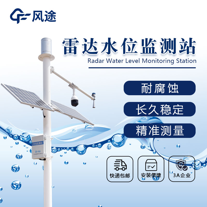
Float-type and pressure-type sensors are prone to being affected by water flow scouring, sediment deposition, water quality corrosion, and floating debris impacts, leading to reduced measurement accuracy, equipment damage, and difficulty in stable operation under severe weather conditions. However, the "non-contact" Water Level Monitoring Station based on radar technology is different.
It adopts K-band (26GHz) planar radar technology. During operation, the radar water level sensor antenna emits radar pulses, which are reflected back from the water surface and received by the antenna, with the time (T) recorded. Since the propagation speed of electromagnetic waves (C) is constant, the distance to the water surface (D) can be calculated using the formula: D = C×T/2. The system performs 55 measurements per second, and through digital filtering processing, it converts nanosecond-level time measurements into millisecond-level data, significantly reducing the impact of water waves on measurement results. The measurement results are nearly equivalent to those of still water level measurements.
With high measurement accuracy reaching the millimeter level and a measurement range of up to 30 meters, its horn antenna design reduces power consumption, and it has a wide input voltage range, making it specially suitable for automatic stations in unmanned field applications. The measurement process is unaffected by factors such as atmospheric temperature, pressure, air density, wind, precipitation, and relative humidity, ensuring extremely strong stability.
In conventional water level monitoring scenarios such as lakes, rivers, reservoirs, open channels, wetlands, and tidal water levels, it stably provides accurate data. In areas with easily changing water quality, its non-contact feature avoids equipment corrosion caused by water quality. In ditches with abundant floating debris and sediments, as well as places with heavy aquatic plant growth, it does not suffer from reduced measurement accuracy due to debris interference. In solar-powered, remote field locations, and mountain flood-prone areas, its low-power consumption and high-stability characteristics make it an ideal choice.
It can also collect water level and rainfall data, featuring real-time clocks, timed storage, parameter setting, and power-off protection for historical parameter data. Equipped with standard RS232/485 communication functions and supporting the MODBUS communication protocol, it can form monitoring systems with computers through various communication methods, including wired connections, mobile wireless GPRS, and wireless data transmission radios. Capable of real-time monitoring and early warning, it automatically triggers an early warning mechanism when water levels are abnormal, sending warning messages to relevant personnel through multiple channels. It can also automatically record and store monitoring data, supporting historical data query and analysis to provide a scientific basis for water resource management decisions.
The oil density sensor employs a piezoelectric resonant MEMS core component, integrating high-precision signal acquisition and intelligent algorithms to synchronously measure liquid density, dynamic viscosity, and temperature in real time. It is suitable for equipment such as hydraulic power s...
Although the Air quality monitoring station is a fixed facility, its greatest advantage lies in its ability to achieve a high-density and refined regional monitoring layout.There are a limited number of large-scale air quality monitoring stations, and they are sparsely distributed. They can of...
Water Level Monitoring Station is a technological facility that uses low-power intelligent sensing devices as its core to continuously monitor the water levels of rivers and lakes,This system provides decision support for flood control, disaster reduction, and water resource management by accurately collecting hydrological data....
Rainfall and water level are important factors affecting reservoir safety. As an indispensable part of rainfall observation system, automatic rainfall level monitoring station plays a very important role in flood prevention. There are some problems in the traditional hydrological forecasting methods...


 Skype
Skype
 whatsapp
 mail
mail