Shandong Fengtu IOT Technology Co., Ltd
Sales Manager:Ms. Emily Wang
Cel,Whatsapp,Wechat:+86 15898932201
Email:info@fengtutec.com
Add:No. 155 Optoelectronic Industry Accelerator, Gaoxin District, Weifang, Shandong, China


Sales Manager:Ms. Emily Wang
Cel,Whatsapp,Wechat:+86 15898932201
Email:info@fengtutec.com
Add:No. 155 Optoelectronic Industry Accelerator, Gaoxin District, Weifang, Shandong, China
Model:FT-SQ17
Brand:fengtu
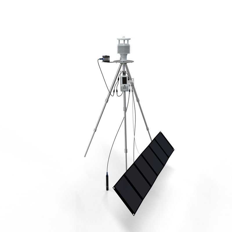
1.Ambient Weather Station Handheld Product Introduction
ambient weather station handheld is a portable weather observatory that can measure wind direction, wind speed, temperature, humidity, air pressure, light and other factors in real time.This product provides real-time measurement of parameters such as temperature, humidity, atmospheric pressure, wind speed, wind direction, light, total radiation, ultraviolet radiation, runway temperature, etc.
It also has functions such as outdoor SOS rescue, electronic compass, runway temperature, weather forecast for the next 3 hours, human comfort, radio silence, GNSS positioning, etc.
At the same time, wireless transmission (4GCat1) and WiFi upload to cloud platform or local area network server are realized, and USB can read internal storage data.
This instrument can be widely used in meteorology, environmental protection, airports, agriculture and forestry, hydrology, military, warehousing, scientific research and other fields.
2. Ambient Weather Station Handheld Technical Parameters
| Meteorological parameters | Measuring features | Measuring range | Accuracy | Resolution | unit |
| temperature | -45-130 | ±0.2 | 0.01 | ℃ | |
| humidity | 0-100 | ±2.0 | 0.01 | % | |
| Atmospheric pressure | 30-110 | ±0.01 | 0.01 | KPa | |
| Wind speed | 0-40 | ±1 | 0.01 | m/s | |
| wind direction | 0-359 | ±1 | 1 | ° | |
| illumination | 0-157286 | <±3% | 1 | Lux | |
| Total radiation | 0-1242 | <±3% | 1 | W/㎡ | |
| UV rays | 0-262144 | <±3% | 1 | mW/㎡ | |
| Runway temperature | -40- 85 | ±0.5 | 0.01 | ℃ | |
| Electronic compass | 0-359 | 1 | 1 | Spend | |
| GNSS positioning | Positioning accuracy 2m | ||||
| SOS | International Morse Code distress signal | ||||
| Battery | 3800mAh | ||||
| Communications | 4G Cat1, Wifi, USB | ||||
| Radio Silence | Disable device 4G CAT1 communication and enter airplane mode | ||||
| Human comfort | Calculate the current human comfort level based on the SET model | ||||
| Weather forecast for the next 3 hours | Deduces three-hour weather conditions based on temperature, humidity, atmospheric pressure, light, ultraviolet rays, wind speed and other information | ||||
| storage | 6MB storage (90,000 records) | ||||
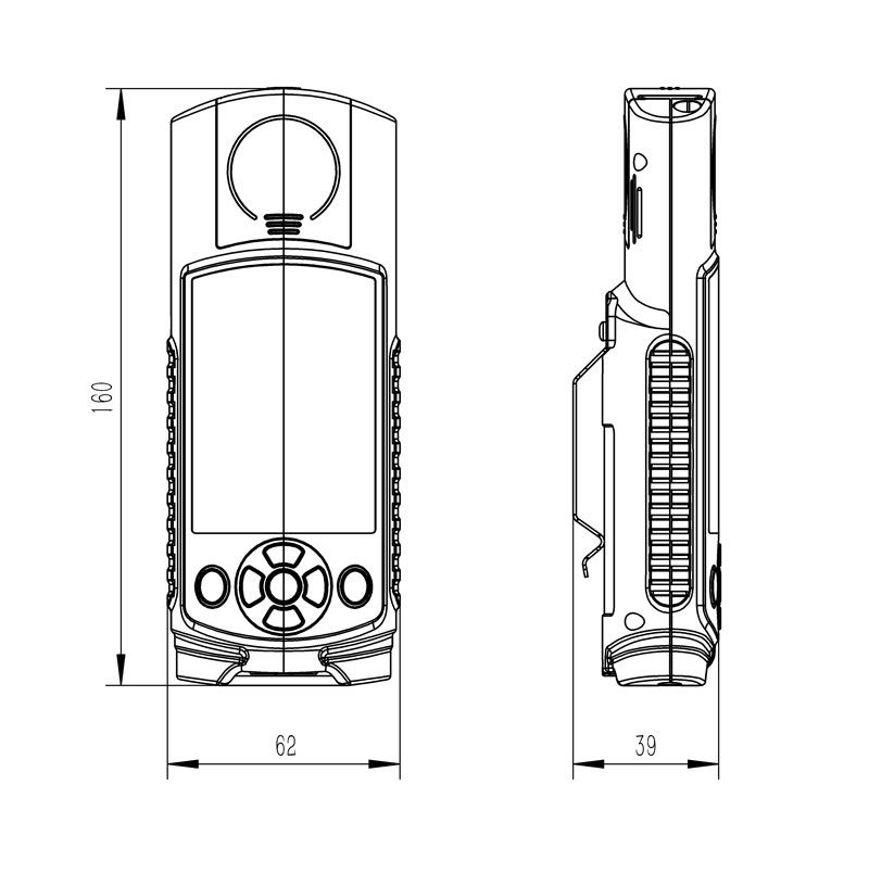
| Host size | 160*62*40 mm | ||||
| working environment | -20℃~80℃; 5%RH~95%RH | ||||
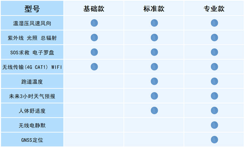
3. Ambient Weather Station Handheld Configuration Instructions
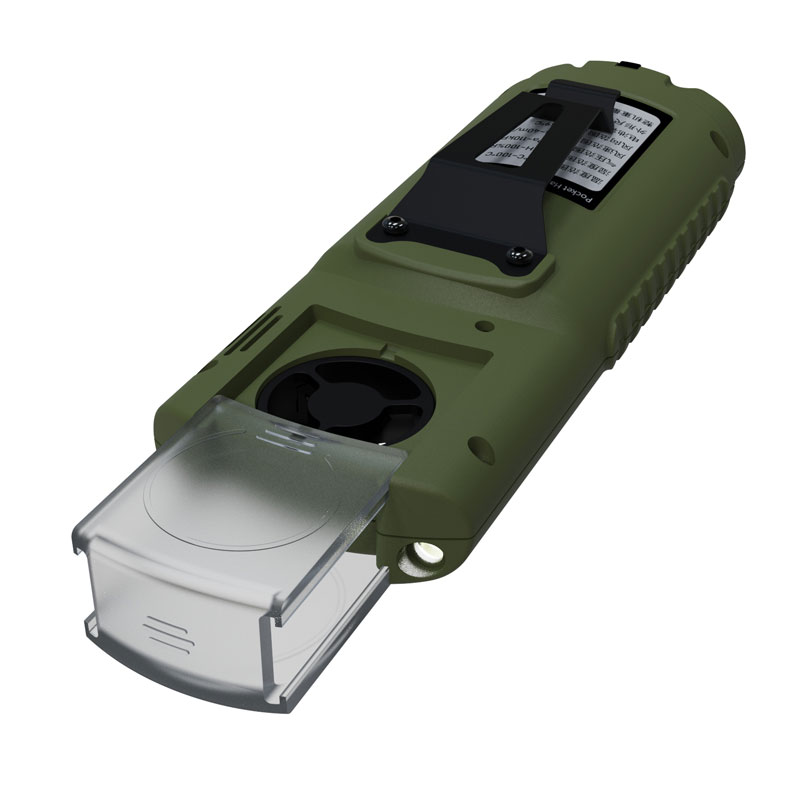
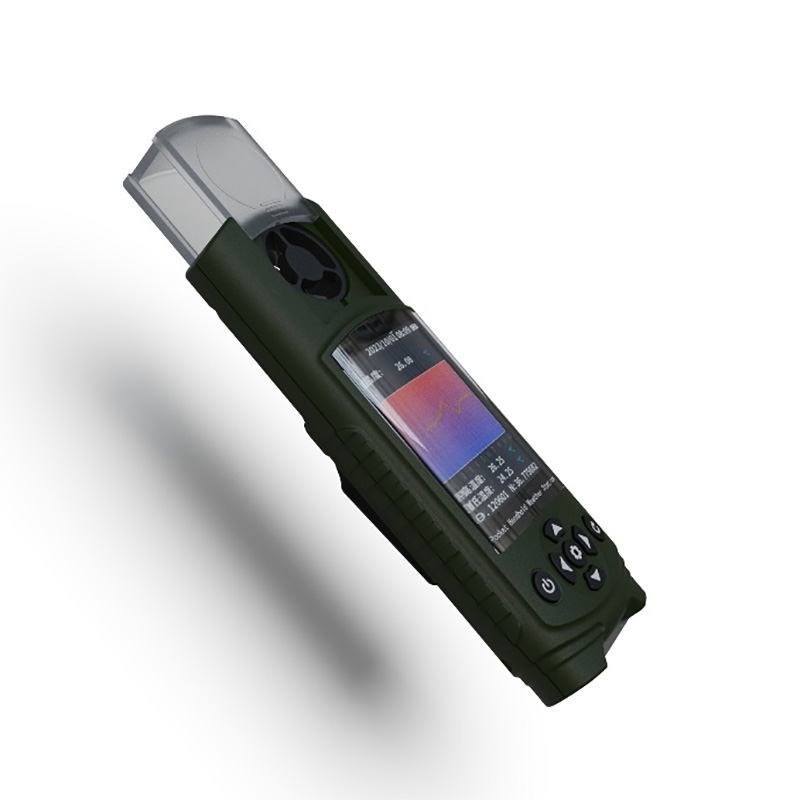
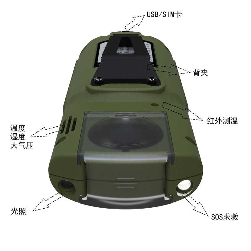
4. Ambient Weather Station Handheld Product Appearance
5. Ambient Weather Station Handheld Product Dimensions
6. Ambient Weather Station Handheld Shipping List
| name | quantity |
| Host | 1 |
| charger | 1 |
| Data cable | 1 |
| manual | 1 |
| Certificate | 1 |
| Warranty Card | 1 |
| Packing box | 1 |
In the field of soil and water conservation research, runoff plots are important observation units. They refer to enclosed observation areas with a certain area and boundaries demarcated on sloping or flat land for studying the laws of soil erosion. These areas, equipped with enclosing ridges, catch...
weather instrument is mainly used to monitor and record various physical parameters in the atmospheric environment. It is composed of meteorological data acquisition, transmission, analysis and processing system....
automatic weather station is used to measure the surface weather observation results. It is a device that can automatically measure, store, and upload meteorological data....
Wind Speed Gauge utilizes an integrated two-parameter sensor to provide all-weather monitoring of wind speed and direction data. The device detects airflow conditions by emitting continuous, variable-frequency ultrasonic signals and measuring the resulting relative phase shifts. It offers a wi...


 Get a Free Quote
 Skype
Skype
 whatsapp
 mail
mail