Shandong Fengtu IOT Technology Co., Ltd
Sales Manager:Ms. Emily Wang
Cel,Whatsapp,Wechat:+86 15898932201
Email:info@fengtutec.com
Add:No. 155 Optoelectronic Industry Accelerator, Gaoxin District, Weifang, Shandong, China


Sales Manager:Ms. Emily Wang
Cel,Whatsapp,Wechat:+86 15898932201
Email:info@fengtutec.com
Add:No. 155 Optoelectronic Industry Accelerator, Gaoxin District, Weifang, Shandong, China
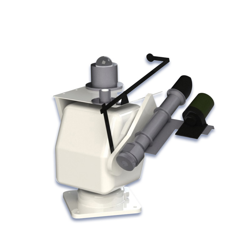
Model:FT-GZ1
Brand:fengtu
1.Fully Automatic Sun Tracker Product Overview
Fully Automatic Sun Tracker is an advanced unattended solar radiation instrument, which solves the problem of manual maintenance of solar radiation instruments.The global universal digital high-precision Fully Automatic Sun Tracker is an unattended high-precision sun tracker independently developed by our company based on the combination of advanced technologies at home and abroad. It can accurately observe the total, direct and scattered solar radiation at any location in the world. This tracker uses an original imported four-quadrant solar sensor, which can automatically compensate for mechanical deviations. It is the only device that can achieve high-precision sun tracking in China so far. It is widely used in many fields such as photovoltaic environment monitoring, meteorological radiation observation, agricultural and forestry scientific research, etc.
2. Fully Automatic Sun Tracker Product Features
1. Global use: The system has a built-in GPS positioning module, which automatically initializes and automatically determines the location after power-on, automatically calculates the sun's trajectory and identifies the status of the northern and southern hemispheres, effectively ensuring that the solar tracker can work normally worldwide.
2. Dual-mode tracking: optical tracking and GPS tracking. The optical tracking mode is used on sunny days with a tracking accuracy of <0.1°. The GPS tracking mode is often used on cloudy days with a tracking accuracy of <0.5°.
3. Good compatibility: It can be equipped with all types of direct radiation and scattered radiation sensors on the market, with super high compatibility.
4. Bluetooth communication: The use mode of the solar tracker can be set through Bluetooth wireless communication. There are mainly three modes: transportation mode, test mode, and working mode. Different working modes are used in different states.
5. All-weather type: There are two models to choose from according to different usage environments. The normal temperature type has a usage temperature of -20 to +55°C and is suitable for the southern region, and the low temperature type has a usage temperature of -40°C to +55°C and is suitable for the northern region.
3. Fully Automatic Sun Tracker Technical Specifications
| Technical Parameters | Measuring range |
| Motor Type | Stepper Motor |
| Tracking Mode | Sun-sensor active mode |
| Calculation passive mode | |
| Pointing accuracy | <0.1° (active tracking, requires sun sensor) <0.5° (passive tracking, GPS calculation) |
| Angular speed | Maximum 4.5°/s |
| Rotation Angle | Horizontal 0~350°, vertical 0~120° |
| GPS measurement method | Time service + date calculation |
| Torque | 12 Nm |
| Payload | 17 kg |
| Communication interface | Wireless Bluetooth |
| Protection level | IP66 |
| Power supply mode | DC12V |
| Work Environment | Temperature -20℃~+55℃ (normal temperature type) Temperature -40℃~+55℃ (low temperature type) |
| Humidity 0~85%RH | |
| Product size | 235(W)×181(D)×310(H) mm |
| weight | 6kg |
Explosion-proof automatic weather station, mainly used for environmental monitoring and management in electric power, petroleum, chemical and other industries, is a meteorological observation instrument. It can monitor the changes of various meteorological data in the atmosphere exactly within a cer...
Rainfall monitor is specially designed for flash flood and meteorological disaster early warning. It is easy to install, has low power consumption, long wireless transmission distance and low maintenance cost. It can conduct detailed minute-level monitoring of rainstorms. These stations are located...
An ultrasonic wind speed and direction meter is a device that uses ultrasonic technology to determine the speed and direction of wind. It can be used in field environments, as well as indoors for inspection and maintenance work on buildings, and for determining meteorological parameters. Its sensor...
Currently, the development of ice sensing technology is quite mature, with dozens of detection principles and methods available. According to differences in principles, ice sensors can be categorized into optical, electrical, mechanical, thermal, waveguide, and other types. Among them, the electrica...


 Get a Free Quote
 Skype
Skype
 whatsapp
 mail
mail