Shandong Fengtu IOT Technology Co., Ltd
Sales Manager:Ms. Emily Wang
Cel,Whatsapp,Wechat:+86 15898932201
Email:info@fengtutec.com
Add:No. 155 Optoelectronic Industry Accelerator, Gaoxin District, Weifang, Shandong, China


Sales Manager:Ms. Emily Wang
Cel,Whatsapp,Wechat:+86 15898932201
Email:info@fengtutec.com
Add:No. 155 Optoelectronic Industry Accelerator, Gaoxin District, Weifang, Shandong, China
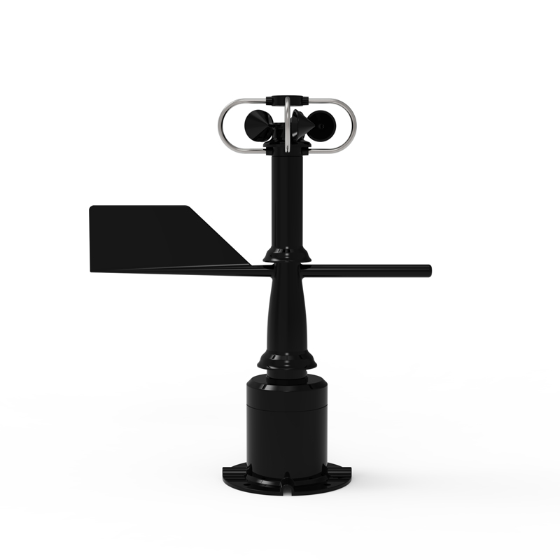
Model:FS485
Brand:fengtu
1.Wind speed and direction sensor technical indicators
Wind speed and direction sensor is an integrated wind speed and direction measurement function of the sensor equipment, the use of polymer engineering plastics, high strength, good start-up.
Power supply: DC12V
Working environment: -40~70℃, humidity ≤100% without condensation
Communication interface: RS485
Operating current: 55mA DC12V
Starting wind speed: 0.5m/s
Minimum data interval: 0.5S
Housing material: polymer engineering plastic
2.Wind speed and direction sensor parameters
| parameter | Measurement range | Resolution | Accuracy |
| Wind speed | 0-60m/s | 0.01m/s | ±0.2m/s |
| wind direction | 0-360 degrees | 0.1 degree | ±1 degree |
| Average wind speed | 0-60m/s | 0.01m/s | ±0.2m/s |
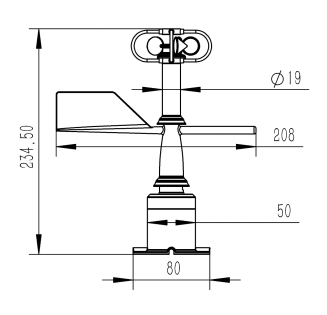
3.Wind speed and direction sensor appearance size
4.Wind speed and direction sensor installation requirements
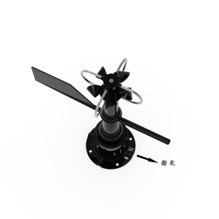
When installing, the direction of the base arrow N must be directed to the north (as shown in the figure above)
anemometer measures is a measuring device that measures the wind speed. It is a commonly used instrument in weather stations....
Stainless Steel Duct Air Velocity Sensor is a kind of sensor specially designed to measure the airflow velocity inside the duct, which can be widely used in air-conditioning system, factory ventilation, mine ventilation, environmental monitoring and other occasions. In the pipeline, the airflow spee...
At present, the ultrasonic wind speed and direction meter has become a relatively advanced wind speed and direction measuring instrument. Because it can better overcome the inherent shortcomings of the mechanical wind speed and direction meter, so that it can be all-weather long time normal operatio...
Winter wheat and summer corn have their own requirements for soil moisture conditions. For winter wheat, a soil relative water content of 70% - 75% is ideal for sowing, which facilitates seed-soil contact and germination. Too dry or too wet conditions can affect germination and seedling growth. Duri...


 Get a Free Quote
 Skype
Skype
 whatsapp
 mail
mail