Shandong Fengtu IOT Technology Co., Ltd
Sales Manager:Ms. Emily Wang
Cel,Whatsapp,Wechat:+86 15898932201
Email:info@fengtutec.com
Add:No. 155 Optoelectronic Industry Accelerator, Gaoxin District, Weifang, Shandong, China


Sales Manager:Ms. Emily Wang
Cel,Whatsapp,Wechat:+86 15898932201
Email:info@fengtutec.com
Add:No. 155 Optoelectronic Industry Accelerator, Gaoxin District, Weifang, Shandong, China
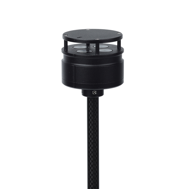
Model:FT-F1
Brand:fengtu
Product Name: Anemometer for drones
Anemometer for drones is an anemometer designed for use on drones and size, weight and power limiting devices.Anemometer for drones Product Introduction: FT-F1 anemometer is an anemometer that uses the ultrasonic resonance principle.
Specially designed and installed on small aircraft and unmanned platforms to monitor wind speed and direction values in low-altitude areas.
The FT-F1 weighs 56g and has a diameter of 46mm, making it small and light. It is compact and solid, has strong anti-electromagnetic interference, waterproof and dustproof functions, and can work normally at an altitude of 4,000 meters and in an external environment with a temperature between -40°C and +70°C.
It uses a low-power chip inside and can measure wind speeds up to 60m/s. It is especially suitable for unmanned aircraft and their related flight control platforms, as well as environmental monitoring systems using aircraft.
FT-F1 is designed with two installation methods: it can be installed vertically on the top of the aircraft or inverted on the bottom of the aircraft.
Anemometer for drones technical indicators:
Wind speed measurement range 0-60m/s, accuracy 3%, resolution 0.1m/s
Wind direction measurement range 0-359°, accuracy ±3°, resolution 1°
Instrument diameter 46mm
Instrument height 48mm
Instrument weight: 56g
Material:ABS
Color Black
Digital output RS485
Baud rate 4800-19200
Communication protocol ModBus, ASCII
Operating temperature/humidity -40℃-+70℃; 0-100%
Working altitude 0-4000 meters
Power requirement VDC: 5-30V; 15mA (12V)
Installation method: Mount on the top column of the aircraft or hang on the bottom
Negative oxygen ion sensors monitor air quality in real time by measuring the concentration of negative oxygen ions in the air. Such sensors usually use electrochemical or optical principles to detect negative oxygen ions and convert the detected signals into readable data through electronic devices...
Wave Height Measurement Instrument is a specialized device dedicated to the monitoring of marine waves and water levels. Equipped with a low-power microprocessor, a high-precision 24-bit AD converter, and a capacitive wave height sensor, it is capable of accurately measuring wave parameters an...
temperature and humidity monitoring Monitor the relative humidity and temperature of indoor or outdoor air to provide accurate data for various applications....
The Remote Rain Level Monitoring system is specifically designed for accurately measuring rainfall, utilizing tipping bucket or piezoelectric sensors for all-weather monitoring....


 Get a Free Quote
 Skype
Skype
 whatsapp
 mail
mail