Shandong Fengtu IOT Technology Co., Ltd
Sales Manager:Ms. Emily Wang
Cel,Whatsapp,Wechat:+86 15898932201
Email:info@fengtutec.com
Add:No. 155 Optoelectronic Industry Accelerator, Gaoxin District, Weifang, Shandong, China


Sales Manager:Ms. Emily Wang
Cel,Whatsapp,Wechat:+86 15898932201
Email:info@fengtutec.com
Add:No. 155 Optoelectronic Industry Accelerator, Gaoxin District, Weifang, Shandong, China
time:2026-10-12 10:04:07 source:Weather Station viewed:3 time
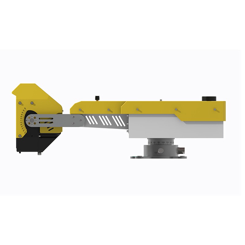
This solution employs a fixed 360° slope deformation monitoring radar that integrates arc-shaped synthetic aperture radar (SAR) and phase-based interferometry. It enables long-range scanning of minute slope displacements, provides 24/7 unattended monitoring, and automatically identifies and issues warnings for landslide and collapse risks.
The system utilizes a compact, fixed 360° slope deformation monitoring radar based on proprietary research from Sun Yat-sen University. By combining arc-shaped SAR architecture with phase-based interferometry, the radar extracts data on minute surface deformations from a distance, making it suitable for slope monitoring in small-to-medium open-pit mines, geological hazard sites, water conservancy projects, and along railway and highway networks.
The device features an edge computing architecture that integrates data processing, positioning and orientation, and wireless communication capabilities directly into the unit, eliminating the need for a complex equipment room. Weighing only 10 kg, the radar supports single-person field deployment and can also be mounted on a trailer platform. It offers a measurement precision of 0.1 mm and a maximum monitoring range of 2,000 meters, providing 360° coverage. The scanning cycle is adjustable between 0.5 and 4 minutes, and the system supports 3D fusion with sub-meter registration to fully capture overall slope deformation. Equipped with separate transmit and receive antennas (providing at least 50 dB of isolation), the unit offers an optional electronically controlled tilt adjustment module with a maximum tilt range of 80 degrees.
The entire monitoring system boasts an IP65 protection rating, ensuring stable operation in temperatures as low as -40°C and at altitudes up to 5,000 meters. It is designed for continuous, exposed field operation without a dedicated monitoring shelter and remains unaffected by adverse conditions such as rain, clouds, fog, snow, dust, or flames. The radar unit features integrated 4G wireless and wired communication modules, with optional built-in positioning and orientation capabilities to meet the field communication and positioning requirements of various projects.
This automated slope monitoring solution is suitable for the long-term monitoring of slopes at small-to-medium-sized mines, temporary monitoring of mine slope collapses, long-term monitoring of potential geological hazard sites, and long-term monitoring of tailings dam structures. The equipment continuously scans slope surface displacement 24/7; the system automatically calculates displacement and deformation rates, assesses slope stability against preset thresholds, and triggers automated early warnings, enabling unattended on-site operation. The solution enables continuous monitoring of deformation trends in slopes and geological bodies, facilitates the early identification of landslide and collapse risks, and provides reliable, continuous deformation data for geological hazard prevention and the safe operation and maintenance of major engineering projects.
Direct radiation sensor is specifically designed to measure the energy of direct solar radiation in the form of parallel light, with a spectral range of 0.28-3μm. Its core component is a high-precision photosensitive element, employing a precise cylindrical optimized design and a quartz glass...
Soil is key to plant growth, and its health directly affects the ability of plants to thrive. Due to natural and man-made factors, soil quality may deteriorate, affecting the environment in which plants can grow. Therefore, it is necessary to monitor soil indicators such as temperature, moisture and...
The role of road weather monitoring system in highway construction is very important, and it is a new type of automatic weather station established on the basis of road weather service. It can not only realize real-time observation of road weather conditions and driving environment, but also provide...
Ultrasonic wind speed sensor principle:It uses ultrasonic time difference method to realize wind speed and wind direction measurement. As the speed of sound propagation in the air, it will be and wind direction. Above the airflow speed iteration. If the ultrasonic propagation direction and the wind...


 Skype
Skype
 whatsapp
 mail
mail