Shandong Fengtu IOT Technology Co., Ltd
Sales Manager:Ms. Emily Wang
Cel,Whatsapp,Wechat:+86 15898932201
Email:info@fengtutec.com
Add:No. 155 Optoelectronic Industry Accelerator, Gaoxin District, Weifang, Shandong, China


Sales Manager:Ms. Emily Wang
Cel,Whatsapp,Wechat:+86 15898932201
Email:info@fengtutec.com
Add:No. 155 Optoelectronic Industry Accelerator, Gaoxin District, Weifang, Shandong, China
time:2026-09-29 09:34:58 source:Weather Station viewed:1 time
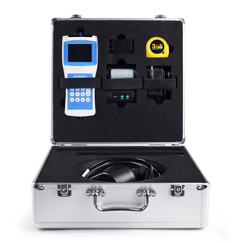
Boat Depth Finder Utilizing ultrasonic ranging principles for precise water depth calculation, this device is suitable for various environments—including rivers, lakes, reservoirs, and shallow coastal waters—and supports measurements in both still and flowing water. Integrating functions such as positioning, data storage, and Bluetooth printing, it serves as a standard professional tool for hydrological surveying and water body monitoring.
Boat Depth Finder is a professional surveying instrument widely used in the fields of water conservancy and hydrology. It operates primarily on the principle of ultrasonic ranging; by placing an ultrasonic transducer beneath the water's surface, it automatically and accurately calculates water depth based on the speed of sound in water and the time taken for sound waves to be transmitted and received. Benefiting from years of technical iteration and optimization, the device combines the strengths of similar products and features dedicated large-scale integrated circuits with a high rate of surface-mount components. Equipped with a high-definition LCD display, it offers robust operational stability and ultra-low power consumption, making it ideal for long-term outdoor surveying operations.
The Boat Depth Finder boasts exceptional environmental adaptability, delivering stable measurements in still water while also performing effectively in flowing waters with velocities up to 5 meters per second, thereby meeting diverse surveying needs. Designed for easy installation either inside or outside the hulls of small-to-medium-sized vessels, it comes with a dedicated 10-meter cable; the unit is portable, simple to operate, and offers rapid measurement response. With a minimum display resolution of 0.1 mm, its measurement precision far exceeds that of conventional surveying equipment, effectively ensuring the accuracy of hydrological data.
In terms of functionality, the Boat Depth Finder integrates a range of practical features, simultaneously displaying water depth, water temperature, coordinates (latitude/longitude), movement speed, date/time, and device status on a single screen. It utilizes a dual-mode BeiDou/GPS positioning system to acquire precise location data in real-time. Additionally, the device incorporates a high-precision clock and a watchdog circuit; with an extremely low annual error rate, it ensures stable, continuous operation over extended periods without system freezes or lag. The storage module utilizes 16MB of flash memory and automatically generates CSV data files using the FAT32 file system; data can be retrieved by connecting to a computer via a USB interface. It also supports wireless Bluetooth printing and long-range RS485 data output, making it suitable for a wide range of data transmission and archiving scenarios.
Characterized by precise measurement, low power consumption, high stability, and multifunctional integration, the Boat Depth Finder is widely used in fields such as hydrological surveying, reservoir area inspection for hydroelectric plants, river and lake surveying, and aquatic environmental monitoring; it can also be mounted on unmanned vessels.
Early summer is so beautiful, the breeze, wheat waves rolling, full of hope for a good harvest. Farmers sweat hard for a good harvest, to use science and technology to guard food security oh!For example, the temperature and humidity sensor chip to help grain monitoring for many years, intelligent gr...
ambient home weather station monitors house and backyard weather conditions and is a versatile personal weather station for local and remote monitoring....
Taking the Dissolved oxygen sensor that measures with the dual-light-source method based on the UV254 absorption method as an example, its measurement principle is based on the ultraviolet absorption method. During operation, the light source inside the instrument emits ultraviolet light, and the li...
best weather station enables you to view temperature, humidity, barometric pressure, wind speed, wind direction, rainfall, etc., and is a fully functional weather station....


 Skype
Skype
 whatsapp
 mail
mail