Shandong Fengtu IOT Technology Co., Ltd
Sales Manager:Ms. Emily Wang
Cel,Whatsapp,Wechat:+86 15898932201
Email:info@fengtutec.com
Add:No. 155 Optoelectronic Industry Accelerator, Gaoxin District, Weifang, Shandong, China


Sales Manager:Ms. Emily Wang
Cel,Whatsapp,Wechat:+86 15898932201
Email:info@fengtutec.com
Add:No. 155 Optoelectronic Industry Accelerator, Gaoxin District, Weifang, Shandong, China
time:2025-04-14 10:02:06 source:Weather Station viewed:655 time
In the natural water cycle system, water level and rainfall amount are two crucial parameters, which can affect human production and life as well as the stability of the ecological environment. Monitoring water level and rainfall data is essential for preventing flood disasters and rationally allocating water resources.
Water Level Monitoring
The water level refers to the elevation of the water surface relative to a certain datum plane. It reflects the changes in the water volume of a water body and is a key indicator in fields such as flood prevention and disaster reduction, water conservancy project dispatching, and shipping safety. During the flood season, a rapid rise in the water level may indicate the approaching of flood disasters. Through real-time monitoring of the water levels of rivers, lakes, reservoirs and other water bodies, relevant departments can promptly grasp the dynamics of the water situation, issue flood warnings in advance, organize the evacuation of the public, and minimize losses of life and property to the greatest extent. Taking the Yangtze River Basin as an example, every flood season, the water level monitoring stations densely distributed in the basin keep working, providing key data for the scientific dispatching of water conservancy hubs such as the Three Gorges Dam, effectively regulating floods, and protecting the safety of tens of millions of people, a large number of farmlands and cities in the middle and lower reaches of the Yangtze River. At the same time, for shipping, accurate water level information can help ships plan their routes reasonably, avoiding running aground due to too low a water level or encountering navigation risks due to too high a water level, ensuring the smooth operation of water transportation.
Rainfall Monitoring
Rainfall monitoring focuses on measuring the depth of rainwater that falls on the ground within a certain period of time, usually in millimeters. It is applied in meteorological forecasting, agricultural production, urban drainage planning and other aspects. The meteorological department relies on widely distributed rainfall monitoring stations to collect precipitation data, so as to accurately predict the time, intensity and scope of rainfall, and provide the public with timely weather forecast services, facilitating people to arrange their daily activities. In the agricultural field, rainfall information is directly related to the growth of crops. Timely and appropriate rainfall is like "sweet rain" for the healthy growth of crops, while excessive or insufficient precipitation may cause flood or drought disasters, affecting crop yields. Accurate rainfall monitoring can help farmers rationally arrange agricultural activities such as irrigation and fertilization, improve agricultural production efficiency, and ensure food security. In urban construction, rainfall monitoring data provides a basis for the planning and management of urban drainage systems. Understanding the rainfall intensity and frequency in different areas helps to optimize the design of drainage pipelines, avoid urban waterlogging, and enhance the city's ability to cope with extreme weather.
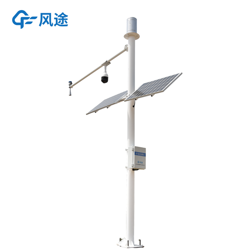
Water Level Monitoring Station
With the rapid development of science and technology, in order to obtain hydrological information more efficiently and comprehensively, the integrated water level and rainfall monitoring device integrates the functions of water level monitoring and rainfall monitoring, achieving the synchronous measurement and data integration of these two key hydrological parameters. Its core components are high-precision water level sensors and rainfall sensors. There are many types of water level sensors. For example, the radar water level sensor measures the water level in a non-contact manner, is not affected by the corrosiveness of the water body, and is suitable for field environments. The commonly used rainfall sensor is the tipping bucket rain gauge. When it rains, the rainwater enters the tipping bucket. When the amount of rainwater in the tipping bucket reaches a certain level, the tipping bucket turns over. The amount of rainfall is measured by recording the number of times the tipping bucket turns over, which has the advantages of simple structure and accurate measurement.
The data collection module of the integrated monitoring device can quickly and accurately collect the data measured by the sensors, and perform preliminary processing and storage. The transmission module, with the help of wireless communication technologies such as GPRS, 4G and even 5G networks, transmits the data to the monitoring center in real time. This enables the staff, regardless of where they are, to obtain the latest water level and rainfall information in a timely manner, realizing remote monitoring and management. In some remote areas or field environments, the device can be equipped with solar panels and storage batteries, using solar energy for power supply to ensure that the device can operate continuously and stably even without the supply of mains electricity.
The integrated water level and rainfall monitoring device has intelligent functions. It can automatically determine whether the water level and rainfall amount are beyond the normal range according to the set thresholds. Once an abnormality occurs, it will immediately send a warning message to the relevant departments, winning precious time for emergency response. Moreover, by combining with the Geographic Information System (GIS), the monitoring data can be intuitively displayed on an electronic map, facilitating the staff to analyze the hydrological conditions in different areas and make scientific and reasonable decisions.
2D Ultrasonic Anemometer is a precision measuring instrument based on the ultrasonic time-of-flight principle, capable of simultaneously measuring horizontal wind speed and direction. The device features an integrated stainless steel design, a robust structure, fast response speed, and accurate measurement data....
Measuring visibility is crucial for ensuring traffic safety, especially in fields such as highways, railways, aviation, and shipping. Low visibility significantly increases the risk of accidents. Visibility data is very important for improving the accuracy of weather forecasts, conducting climate re...
rain gauge how does it work Falling rainwater is collected in a container and measured to determine the depth of precipitation occurring per unit area, usually measured in millimeters....
Grid-based air quality monitoring is an air quality monitoring method based on grid-based spatial distribution. The monitoring area is divided into grid cells, and air quality monitoring data from air quality monitoring stations and meteorological data are used to predict and assess the air quality...


 Skype
Skype
 whatsapp
 mail
mail