Shandong Fengtu IOT Technology Co., Ltd
Sales Manager:Ms. Emily Wang
Cel,Whatsapp,Wechat:+86 15898932201
Email:info@fengtutec.com
Add:No. 155 Optoelectronic Industry Accelerator, Gaoxin District, Weifang, Shandong, China


Sales Manager:Ms. Emily Wang
Cel,Whatsapp,Wechat:+86 15898932201
Email:info@fengtutec.com
Add:No. 155 Optoelectronic Industry Accelerator, Gaoxin District, Weifang, Shandong, China
time:2026-02-24 10:07:29 source:Weather Station viewed:358 time
Settlement monitoring system utilizes differential RTK technology to achieve millimeter-level displacement monitoring, continuously observing vertical surface displacement through GNSS base stations and IoT sensor networks. This technology system can be widely applied in engineering fields such as dam safety monitoring, bridge health monitoring, and landslide early warning, providing data support for preventing structural damage caused by land subsidence.
Land subsidence is a significant geological hazard that cannot be ignored in urban construction and operation management. Land subsidence can lead to various problems such as structural damage, pipeline leaks, and uneven roads, and in severe cases, even threaten the lives and property of the people. By implementing online subsidence monitoring, the ground subsidence situation can be grasped in real time, providing a scientific basis for engineering safety assessment and risk early warning.
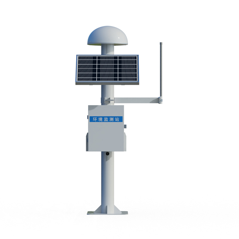
Currently, the core technology of Settlement monitoring system is differential RTK technology, a high-precision positioning method based on the Global Navigation Satellite System that can achieve millimeter-level displacement monitoring. Taking a GNSS displacement monitoring station as an example, its static accuracy can reach ±2.5mm+1ppm in the horizontal direction and ±5mm+1ppm in the vertical direction, accurately calculating the three-dimensional coordinates of the monitoring point and capturing minute displacement changes. The monitoring station typically uses solar power and 4G transmission, supporting 24/7 real-time monitoring to ensure data timeliness and accuracy.
In practical engineering applications, [Company Name] has constructed a multi-technology integrated three-dimensional monitoring network. Space-based monitoring uses improved time-series InSAR technology, utilizing continuous satellite radar imagery to achieve millimeter-level surface deformation detection, providing large-scale, continuous deformation monitoring for areas such as subway lines and road subsidence zones. Ground-based monitoring is based on an NB-IoT Internet of Things sensor network, enabling real-time acquisition of structural responses such as settlement, tilt, and cracks, maintaining stable data acquisition capabilities even in weak signal environments. Furthermore, the construction of deep leveling piles and stratified monitoring wells is also crucial, allowing for independent monitoring of different soil layers by drilling into stable strata and setting bedrock and stratification markers.
The installation of Settlement monitoring system has strict technical requirements. The recommended distance between the base station and the measuring station is less than 500 meters, and should not exceed 2 kilometers; excessive distance will lead to decreased accuracy. Simultaneously, tall buildings should be avoided from obstructing the monitoring station, the antenna must be positioned at its highest point within a 20-meter radius, and the mounting base must be secure to avoid wind-induced errors. For key monitoring areas, such as along high-speed railway lines, layered monitoring groups are deployed every 5 kilometers, and fiber optic grating sensor arrays are installed on the piers of cross-sea bridges to form a dense monitoring network.
The application scenarios of Settlement monitoring system are very extensive. In dam safety monitoring, the system tracks dam displacement changes in real time to prevent the risk of dam failure caused by seepage deformation; in bridge health monitoring, it monitors pier settlement and beam deflection to assess the structural safety status; in landslide early warning, it achieves localized early warning through anomaly detection of displacement rates. The Beijing ground settlement monitoring project has newly built and renovated 48 monitoring facilities, achieving full coverage automated monitoring in key areas and improving the time resolution of monitoring data to the minute level.
With technological advancements, [the system] is evolving towards an integrated space-air-ground system. Through a complete technological system encompassing satellite macro-monitoring, real-time ground sensor monitoring, intelligent analysis and early warning, and 3D visualization, it achieves comprehensive monitoring from macro to micro levels and from intermittent to continuous operation. This system not only significantly reduces the cost of manual inspections but also enables the early detection of potential risks such as ground subsidence and structural damage, providing reliable assurance for safe urban operation and the full lifecycle management of major projects.
best home weather station conducts real-time observations of indoor and outdoor temperature, humidity, barometric pressure, optical rainfall, pm2.5, pm10 and other meteorological elements....
Today, I will introduce the rain monitoring station manufacturer - Fengtu Technology, a professional meteorological and environmental equipment supplier!If you want to buy rain monitoring stations and rain monitoring sensors, please visit the company's website www.fengtutec.com!Rainfall monitori...
Soil moisture meter is the most suitable equipment for soil moisture monitoring, which is a scientific instrument specialized in measuring soil moisture. It mainly uses sensors to collect soil moisture in real time and transmit the data to the background, and then analyzes and calculates the corresp...
A soil moisture monitoring system is a set of equipment used to continuously detect soil moisture, which is helpful for farmers to grow their crops. This system measures soil moisture conditions by placing sensors at different depths as needed. It also measures soil temperature and other soil proper...


 Skype
Skype
 whatsapp
 mail
mail