Shandong Fengtu IOT Technology Co., Ltd
Sales Manager:Ms. Emily Wang
Cel,Whatsapp,Wechat:+86 15898932201
Email:info@fengtutec.com
Add:No. 155 Optoelectronic Industry Accelerator, Gaoxin District, Weifang, Shandong, China


Sales Manager:Ms. Emily Wang
Cel,Whatsapp,Wechat:+86 15898932201
Email:info@fengtutec.com
Add:No. 155 Optoelectronic Industry Accelerator, Gaoxin District, Weifang, Shandong, China
time:2025-07-31 09:19:35 source:Weather Station viewed:882 time
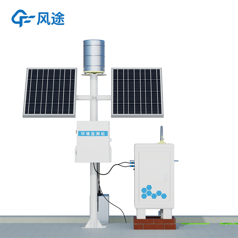
In the field of soil and water conservation research, runoff plots are important observation units. They refer to enclosed observation areas with a certain area and boundaries demarcated on sloping or flat land for studying the laws of soil erosion. These areas, equipped with enclosing ridges, catchment troughs, and measuring devices, can accurately monitor the processes of runoff and sediment transport under specific conditions, serving as a basic platform for researching soil erosion mechanisms and evaluating the effectiveness of prevention and control measures. Under conditions such as rainfall or snowmelt, surface flowing water forms in the runoff plots, and the amount of sediment carried directly reflects the intensity of soil erosion in the area.
Soil erosion, as a global ecological problem, not only leads to reduced soil fertility and land degradation but also may trigger natural disasters such as floods and mudslides, seriously affecting the ecological environment and human production and life. Therefore, the monitoring and research of runoff and sediment in plots are important measures for preventing and controlling soil erosion and protecting the ecological environment.
Soil Erosion Monitoring emerged in this context. It integrates advanced sensor technology, automated data collection and processing systems, and remote communication technology, becoming a tool for soil and water conservation monitoring and ecological protection. The core component of this monitor – the sensor – features high sensitivity, high precision, and long-term stability, enabling real-time monitoring of sediment content in runoff. Through the built-in automated data collection and processing system, the data collected by the sensor can be quickly converted into intuitive sediment concentration information and stored in the built-in data storage. With the help of remote communication technology, monitoring data can be uploaded to cloud servers or management centers in real-time, realizing remote access and sharing of data.
On one hand, it can achieve real-time monitoring and accurate data acquisition. Traditional monitoring methods rely on manual sampling and laboratory analysis, which have limitations such as poor timeliness and fragmented data, making it difficult to dynamically record the soil erosion process. In contrast, the automatic monitor can realize synchronous monitoring of total runoff and sediment content, record changes in runoff velocity and water volume in real-time, and quickly calculate the concentration of suspended solids in water based on the light scattering characteristics of sediment particles. The integrated design supports underground or open channel installation in runoff plots, enabling long-term stable operation in outdoor environments and automatically recording the runoff-sediment coupling dynamics during rainfall events, providing detailed data basis for studying the laws of soil erosion.
On the other hand, the system can assist in judging the changing trends based on historical runoff and sediment data, providing references for relevant departments to formulate response plans. At the same time, combined with Geographic Information System (GIS) and remote sensing images, the monitor can also evaluate the comprehensive soil erosion risk levels of different runoff plots, optimizing resource allocation and engineering scheduling strategies.
Data from multiple monitoring stations can be summarized, compared, and visually displayed through a unified soil and water conservation or ecological environment management platform, facilitating departments such as water conservancy, agriculture, and environmental protection to comprehensively grasp the trends of runoff and sediment changes in different regions and the effectiveness of soil and water conservation measures. In key soil erosion control areas, a runoff and sediment monitoring network covering critical regions can be established to provide data support for the layout of soil and water conservation projects and vegetation restoration plans; in agricultural production areas, it can be used to evaluate the impact of different tillage methods on soil erosion, assisting in formulating conservation tillage systems.
best weather station enables you to view temperature, humidity, barometric pressure, wind speed, wind direction, rainfall, etc., and is a fully functional weather station....
Fengtu, as a professional Manufacturers of rainfall and precipitation monitoring equipment, provides a fully automatic online hydrological monitoring system based on microwave technology. This system can synchronously and accurately measure channel water levels and rainfall, enabling real-time data acquisition and information management of water and rainfall conditions....
rain gauge wireless for wireless transmission of precipitation, Rain Gauge Wireless is a high-precision, long-range rain gauge that easily and accurately determines rainfall....
A soil moisture monitoring system is a set of equipment used to continuously detect soil moisture, which is helpful for farmers to grow their crops. This system measures soil moisture conditions by placing sensors at different depths as needed. It also measures soil temperature and other soil proper...


 Skype
Skype
 whatsapp
 mail
mail