Shandong Fengtu IOT Technology Co., Ltd
Sales Manager:Ms. Emily Wang
Cel,Whatsapp,Wechat:+86 15898932201
Email:info@fengtutec.com
Add:No. 155 Optoelectronic Industry Accelerator, Gaoxin District, Weifang, Shandong, China


Sales Manager:Ms. Emily Wang
Cel,Whatsapp,Wechat:+86 15898932201
Email:info@fengtutec.com
Add:No. 155 Optoelectronic Industry Accelerator, Gaoxin District, Weifang, Shandong, China
time:2025-01-17 15:28:47 source:Weather Station viewed:769 time
1.Product introduction of best professional weather station
best professional weather station provides indoor and outdoor temperature and humidity, wind speed and direction, air pressure and rainfall.
This product provides real-time measurement of parameters such as temperature, humidity, atmospheric pressure, wind speed, wind direction, illumination, total radiation, ultraviolet radiation, runway temperature, etc.
It also has functions such as outdoor SOS, electronic compass, runway temperature, weather forecast for the next three hours, human comfort, radio silence, and GNSS positioning.
At the same time, wireless transmission (4GCat1), WiFi upload to cloud platform or local area network server are realized, and internal storage data can be read by USB.
This instrument can be widely used in meteorology, environmental protection, airports, agriculture and forestry, hydrology, military, warehousing, scientific research and other fields.
2.Technical parameters of best professional weather station
| Meteorological parameters | Measurement elements | Measuring range | Accuracy | resolution | unit |
| temperature | -45-130 | ±0.2 | 0.01 | ℃ | |
| humidity | 0-100 | ±2.0 | 0.01 | % | |
| atmospheric pressure | 30-110 | ±0.01 | 0.01 | KPa | |
| wind speed | 0-40 | ±1 | 0.01 | m/s | |
| wind direction | 0-359 | ±1 | 1 | ° | |
| illumination | 0-157286 | <±3% | 1 | Lux | |
| total radiation | 0-1242 | <±3% | 1 | W/㎡ | |
| UV rays | 0-262144 | <±3% | 1 | mW/㎡ | |
| runway temperature | -40- 85 | ±0.5 | 0.01 | ℃ | |
| electronic compass | 0-359 | 1 | 1 | Spend | |
| GNSS positioning | Positioning accuracy 2m | ||||
| SOS for help | International Morse Code Distress Signal | ||||
| Battery | 3800mAh | ||||
| communication | 4G Cat1, Wifi, USB | ||||
| radio silence | Disable device 4G CAT1 communications and enter airplane mode | ||||
| human comfort | Calculate the current human body comfort level based on the SET model | ||||
| Weather forecast for the next 3 hours | Deduces three-hour weather conditions based on temperature, humidity, atmospheric pressure, light, ultraviolet rays, wind speed and other information | ||||
| storage | 6MB storage (90,000 pieces of data) | ||||
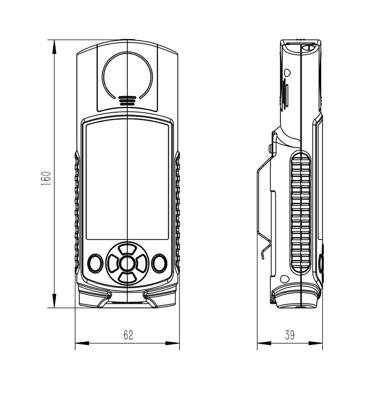
| Host size | 160*62*40mm | ||||
| working environment | -20℃~80℃; 5%RH~95%RH | ||||
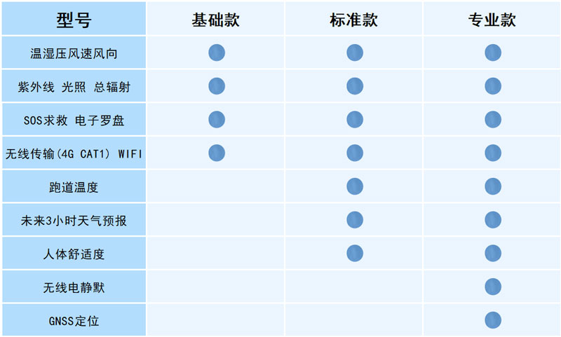
3. Best professional weather station configuration instructions
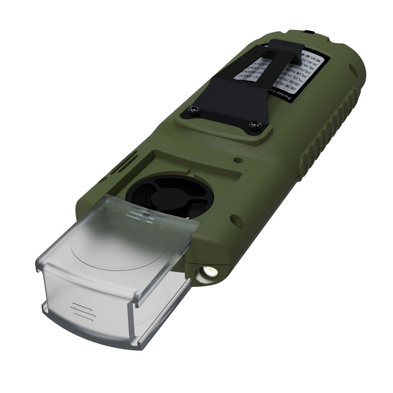
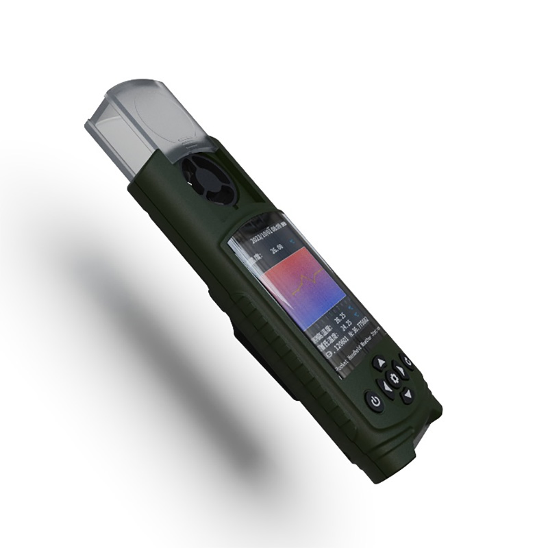
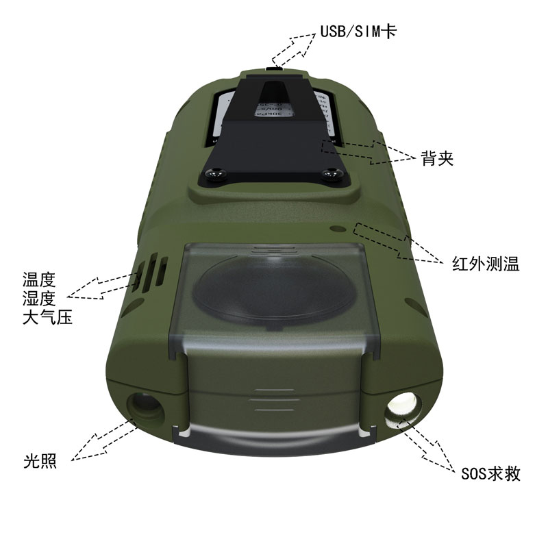
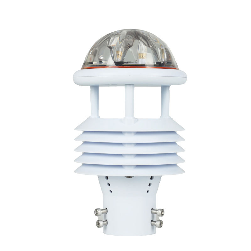
4. Best professional weather station product appearance picture
5. Best professional weather station product size chart
6. best professional weather station delivery list
| name | quantity |
| Host | 1 |
| Charging head | 1 |
| data cable | 1 |
| manual | 1 |
| Certificate | 1 |
| warranty card | 1 |
| Packing box | 1 |
Although the Air quality monitoring station is a fixed facility, its greatest advantage lies in its ability to achieve a high-density and refined regional monitoring layout.There are a limited number of large-scale air quality monitoring stations, and they are sparsely distributed. They can of...
what instrument measures wind direction used to measure wind direction is called an anemometer and records wind speed, direction, and gust strength....
Atmospheric environment monitoring system is a technological platform for real-time online monitoring of regional air quality. It provides continuous 24-hour automatic monitoring of multiple parameters, including PM2.5, PM10, CO, NO2, SO2, O3, wind speed, and temperature....
The five element weather monitor is used to monitor the five elements of weather, namely temperature, humidity, air pressure, wind speed and wind direction. It usually consists of a number of sensors and data loggers that can monitor and record these elements in real time. The five element weather m...


 Skype
Skype
 whatsapp
 mail
mail