Shandong Fengtu IOT Technology Co., Ltd
Sales Manager:Ms. Emily Wang
Cel,Whatsapp,Wechat:+86 15898932201
Email:info@fengtutec.com
Add:No. 155 Optoelectronic Industry Accelerator, Gaoxin District, Weifang, Shandong, China


Sales Manager:Ms. Emily Wang
Cel,Whatsapp,Wechat:+86 15898932201
Email:info@fengtutec.com
Add:No. 155 Optoelectronic Industry Accelerator, Gaoxin District, Weifang, Shandong, China
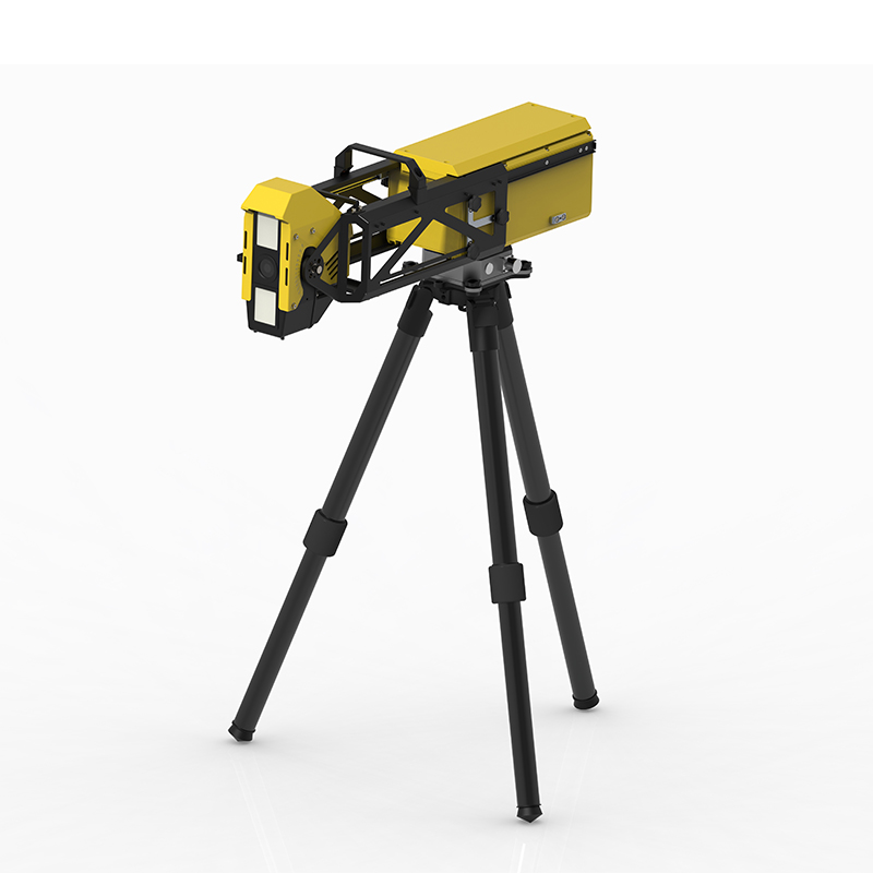
Model:FT-BPLD2
Brand:fengtu
1、Slope Monitoring Radar Product Overview
Slope Monitoring Radar supports single-person carrying and rapid deployment, and is widely used for deformation and settlement monitoring of open-pit mine slopes, hydropower reservoir banks, and dam slopes.The BPLD2 emergency portable 360° Slope Monitoring Radar is based on the proprietary arc-shaped synthetic aperture radar system and phase differential interferometry technology developed by Sun Yat-sen University. It enables non-contact, continuous, and high-precision remote sensing monitoring and timely early warning of slopes, dams, mountains, and buildings at landslide rescue sites, eliminating the safety threats posed by secondary disasters to rescue personnel and equipment.
Slope Monitoring Radar adopts an edge computing architecture, with information processing, positioning, and wireless communication functions all integrated within the device. Weighing less than 10 kg and with a maximum folded size of less than 50 cm, it can be easily carried as baggage or deployed by a single person, allowing for rapid deployment and monitoring by emergency rescue teams at disaster sites. It features 360° wide-range coverage, 0.1mm precision measurement, all-day and all-weather operation, and resistance to harsh environments such as clouds, rain, fog, snow, dust, and fire. It is also specially designed for emergency and rapid response needs, with a lightweight, portable, and low-power design, making it industry-leading in weight, size, power consumption, and portability.
2、Slope Monitoring Radar Application Areas
Landslide Rescue Emergency Monitoring
Mine Side Landslide Emergency Rescue Monitoring
Building Collapse Monitoring (Instability & Fire & Ice Disaster)
Dam Failure Monitoring
3、Slope Monitoring Radar Product Features
Emergency-Specific Version: Specially customized for emergency scenarios
Strong microwave penetration, providing all-weather, 24/7 monitoring capability, unaffected by rain, snow, fog, smoke, dust, or fire.
No Protective Installation Required: Unaffected by outdoor wind, sun, rain, dust, or heavy snow; no monitoring room required.
Adaptive Atmospheric Disturbance Compensation Algorithm
Utilizing circular arc imaging and continuous wave radar, it can monitor 360° all angles, with no blind spots due to angle or distance.
24/7: Continuous scanning
3D Fusion: Sub-meter level registration
All-weather, full-area monitoring
Automatic judgment, automatic early warning, unattended operation
IP65 protection, for emergency use, normal operation at -40℃
Ultra-light and portable, weighing only 10kg, can be carried by one person by hand/on their back for quick access to the rescue site. When folded, its dimensions are only 0.5×0.35×0.25m, which can be placed in a 24-inch storage and transport case, meeting the requirements for onboard baggage handling in civil aviation.
4、Slope Monitoring Radar Key Performance Indicators of Radar and Platform Software
1) Maximum Detection Range: ≥5000m
2) Deformation Accuracy: ≤0.1mm (all azimuth angles)
3) Coverage Area: ≥360°×35°
4) ★Electrically Controlled Pitch Adjustment Angle: ±40° (Electrically controlled, manual adjustment by default)
5) Range Resolution: ≤0.3m
6) Azimuth Resolution: ≤8mrad
7) Acquisition Cycle: Adjustable from 0.5 to 4min
8) Radar Power Consumption: ≤45W
9) ★Radar Weight: ≤10kg, supports tripod mounting
10) ★Supports extendable/retractable configuration for storage Maximum dimensions in state: ≤0.5m
11) ★ Maximum dimensions of packaging box: ≤0.7m
12) Transportability: Can be carried by a single person, can be checked in with flights or high-speed trains.
13) Operating temperature: -40°C~55°C (optional, default -20°C)
14) Protection rating: ≥IP65
15) ★ Radar main unit has a built-in satellite compass, supporting autonomous positioning and orientation (optional)
16) Radar main unit has built-in 4G wireless (optional) and wired communication functions.
17) The main unit uses edge computing, completing all processing internally, eliminating the need for external processing equipment.
18) Deformation drift after atmospheric calibration ≤±1 0.5mm (1000m, 48h)
19) The radar must be domestically developed and manufactured equipment.
20) (Early Warning Software) Supports deployment on physical servers or cloud servers; allows remote device restart; the software adopts a B/S architecture, supporting simultaneous access by multiple users.
21) (Early Warning Software) Supports thematic layer selection and quantitative analysis of feature points or regions, generating curves and reports.
22) ★ (Early Warning Software) Possesses air-varying atmospheric phase correction function; can display deformation maps within a specified time range.
23) (Early Warning Software) Data fusion: Supports UAV modeling, CAD 3D modeling, and laser 3D point cloud modeling data. Fusion with radar data;
24) (Early Warning Software) Features a large-screen monitoring mode; the software interface uses Chinese language; supports curve continuation function;
25) (Early Warning Software) Has 360° imaging capability;
26) ★ (Early Warning Software) Offers free data interface to the client;
27) ★ Supports deformation/rate graded heat map;
28) (Early Warning Software) Supports 4-level automatic judgment and early warning, supports audible, visual, and SMS alarms;
29) ★ (Early Warning Software) Supports generating Word format reports for specified time periods;
30) (Early Warning Software) Allows setting early warning shielding zones to effectively shield false alarms in the work area.
Piezoelectric rain sensors use the impact measurement principle to measure the weight of individual raindrops and thus calculate the amount of rainfall. The raindrops are influenced by the weight of the raindrops and air resistance during their fall. When they reach the ground, the velocity is const...
Road surface condition data is one of the most important parameters of concern for traffic safety, apart from visibility. Whether there is water on the road surface. Snow, ice and other road conditions are one of the safety hazards alerted to. FT-LM2 non-contact road condition detector uses remote s...
Due to the lack of coordination in policy implementation standards, some cities in China still face challenges such as insufficient investment in drainage network construction, overloaded sewage treatment facilities, and coexisting idle equipment. Therefore, it is imperative to construct an urban Dr...
photosynthetically active radiation definition refers to the radiation absorbed by the plant during photosynthesis, namely the solar radiation within the wavelength range of 400 to 700 nm....


 Get a Free Quote
 Skype
Skype
 whatsapp
 mail
mail