Shandong Fengtu IOT Technology Co., Ltd
Sales Manager:Ms. Emily Wang
Cel,Whatsapp,Wechat:+86 15898932201
Email:info@fengtutec.com
Add:No. 155 Optoelectronic Industry Accelerator, Gaoxin District, Weifang, Shandong, China


Sales Manager:Ms. Emily Wang
Cel,Whatsapp,Wechat:+86 15898932201
Email:info@fengtutec.com
Add:No. 155 Optoelectronic Industry Accelerator, Gaoxin District, Weifang, Shandong, China
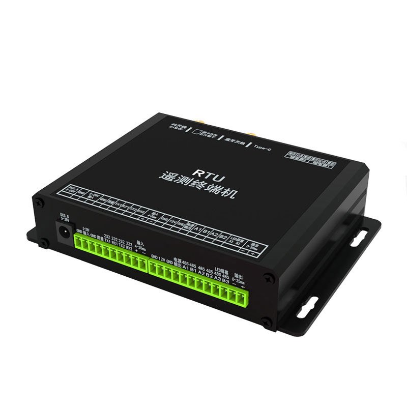
Model:FT-RTU
Brand:fengtu
1、Remote Terminal Unit Product Overview
Remote Terminal Unit is used in various water conservancy information, water affairs information, land disaster information and smart city construction areas.A Remote Telemetry Unit (RTU), also known as a remote terminal unit, is a microprocessor-controlled electronic device primarily used for remote data monitoring and transmission in fields such as meteorology, hydrology, and geology. It connects to a central monitoring station via a distributed control system or SCADA system, and possesses data acquisition, transmission, storage, and remote control capabilities.
Based on application scenarios, it is categorized into types such as hydrological and water resource type, groundwater type, weather station, and geological monitoring station. It can integrate functions such as water level/rainfall monitoring, meteorological monitoring, and pest/soil moisture monitoring, and is suitable for unattended scenarios such as flash flood warning and reservoir monitoring.
2、Remote Terminal Unit Data Reporting Support:
SL651-2014 Hydrological Monitoring Data Communication Protocol
SLT 427—2021 Water Resources Monitoring Data Transmission Protocol
HJ212-2017 Data Transmission Standard for Online Automatic Monitoring (Surveillance) Systems of Pollution Sources
Jiangsu Provincial Hydrological Automatic Measurement and Reporting System Data Transmission Protocol
DB50 469-2012 Chongqing Municipal Hydrological Monitoring Data Communication Protocol
Sichuan Provincial Hydrological Information Acquisition System Information Technology Protocol and Agreement (2018 Revised Edition)
And other provincial platform protocols; please contact us for details.
3、Remote Terminal Unit Device Functionality Support
This device features a low-power design, is compatible with solar power supply scenarios, and supports multiple communication methods including RS232/485, GPRS, Bluetooth, 4G, and BeiDou.
It supports IPv4, IPv6, and domain name connections, allowing for simultaneous multi-IP connections for multi-site data transmission.
The hardware integrates an analog signal input module (4-20mA), a switch signal input module, a relay control interface, and multi-sensor connectivity. It features an industrial-grade protection design and wide operating temperature range (-40℃ to +85℃).
*Built-in temperature and humidity module for real-time monitoring of internal temperature and humidity changes.
Multiple protection circuits prevent short-circuit damage to the device in case of abnormal external forces.
4、Remote Terminal Unit Product dimensions
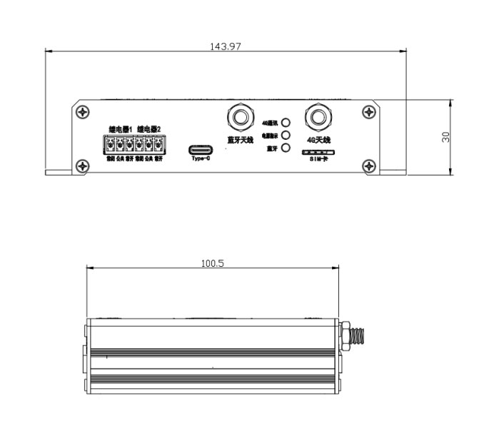
5、Remote Terminal Unit Hardware specifications
| Project | Content |
| Communication module | 4G module for the whole network |
| Hardware interface |
Power input DC monitoring power or terminal access, dual interface design
Power output 1 channel maximum 2A 12V regulated output maximum 0.5A RS485 3-way RS232 2 channels Rainfall 1 channel Enter 4-20ma 1 channel Output 0-25ma 1 channel Relay 2 channels TF card slot 1 piece type-c 1 piece |
| Power supply area | 5-28V |
| Overall power consumption | DC12@25MA |
| 4G Adaptation Network | Full network (Mobile, Telecom, Unicom) |
The 3D Ultrasonic Anemometer is a high-precision gas flow velocity measurement device, which is widely used in meteorological observation, air quality monitoring, meteorological disaster early warning, built environment monitoring, and wind energy resource assessment. The device calculates wind spee...
The GNSS Monitoring Station can detect potential dangers in a timely manner by monitoring mountain displacements with high precision. It can collect the three-dimensional coordinates of monitoring points on the mountain surface in real time, with an accuracy reaching the centimeter or even millimete...
sensors for farming is a powerful tool to collect accurate information of crops, fields and equipment, mainly including light sensors, carbon dioxide sensors, air temperature and humidity sensors, etc....
The Meteorological Disaster Emergency Monitoring and Early Warning System integrates the management of a wide range of meteorological disasters, including, but not limited to, typhoons, droughts, cold waves, dust storms, extreme heat, heavy rainfall and haze. It is able to quickly establish temporar...


 Get a Free Quote

 Skype
Skype
 whatsapp
 mail
mail