Shandong Fengtu IOT Technology Co., Ltd
Sales Manager:Ms. Emily Wang
Cel,Whatsapp,Wechat:+86 15898932201
Email:info@fengtutec.com
Add:No. 155 Optoelectronic Industry Accelerator, Gaoxin District, Weifang, Shandong, China


Sales Manager:Ms. Emily Wang
Cel,Whatsapp,Wechat:+86 15898932201
Email:info@fengtutec.com
Add:No. 155 Optoelectronic Industry Accelerator, Gaoxin District, Weifang, Shandong, China
time:2026-04-02 09:21:39 source:Weather Station viewed:294 time
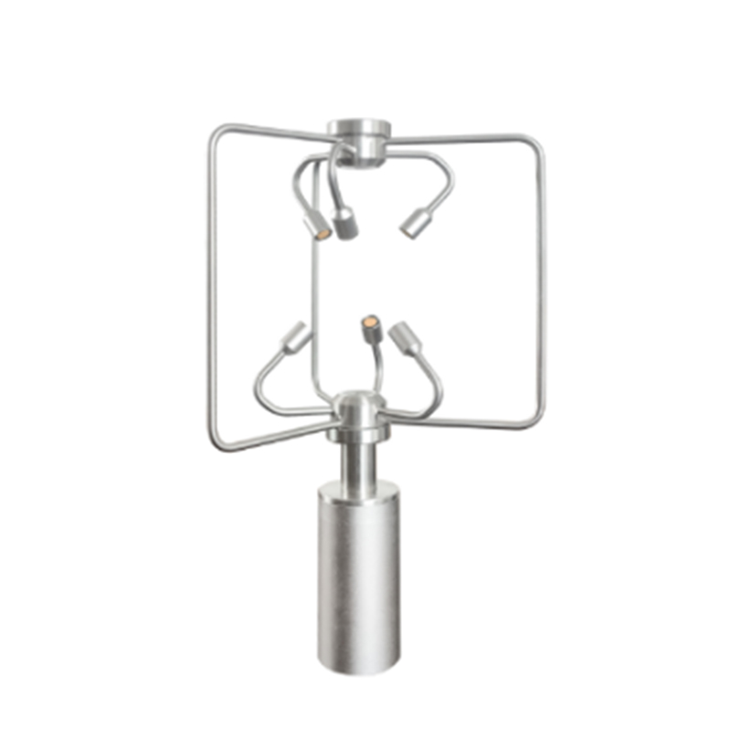
3D Anemometer utilizes ultrasonic technology to measure gas flow velocity, offering a wind speed measurement range of 0–70 m/s with an accuracy of ±3%. Its wind direction range spans 0–360° with an accuracy of ±2°. Constructed from stainless steel, the device is ideally suited for deployment in harsh environmental settings—including those involved in meteorological monitoring, environmental surveillance, and agricultural meteorology.
3D Anemometer is a high-precision meteorological sensor that employs ultrasonic technology to measure gas flow velocity. Unlike traditional mechanical wind cups or wind vanes, this device calculates wind speed and direction by emitting ultrasonic pulses and measuring the time difference of their propagation through the air. This measurement method eliminates the inertial errors associated with mechanical rotating parts, thereby enabling the device to maintain high response speeds and data stability, even under low-wind or turbulent conditions.
In terms of technical specifications, the 3D Anemometer features a wind speed measurement range of 0 to 70 meters per second, achieving a measurement accuracy of ±3% with a resolution precise to 0.1 meters per second. Its wind direction measurement range covers 0 to 360 degrees, with an accuracy of ±2 degrees and a resolution of 0.1 degrees. These specifications enable the device to meet the diverse application requirements of various fields, ranging from meteorological observation to environmental assessment. In scenarios requiring the precise measurement of three-dimensional wind field data, the device provides accurate wind vector information.
The structural design of the device has been carefully engineered to fully account for the complexities inherent in outdoor applications. Constructed entirely from stainless steel, it exhibits robust resistance to corrosion and aging. The stainless steel material ensures the device remains fully functional in demanding measurement environments—including coastal regions subject to salt spray corrosion, industrial zones with high concentrations of pollutants, and high-altitude areas characterized by low-temperature conditions. Furthermore, as the device contains no internal moving parts, it retains its initial measurement accuracy even after prolonged operation, resulting in low maintenance costs.
In terms of practical application, the 3D Anemometer has been widely deployed across various sectors, including meteorological monitoring, environmental surveillance, and agricultural meteorology. In meteorological monitoring, the device is utilized to observe boundary-layer wind field structures and atmospheric turbulence characteristics. In the field of environmental monitoring, it is integrated with air quality monitoring stations to facilitate the analysis of pollutant dispersion pathways and concentration distributions. In the field of agricultural meteorology, 3D Anemometer can provide wind field data support for the calculation of farmland evapotranspiration and the assessment of crop growth environments.
Designed with a durable ABS housing, Windway's Ultrasonic Wind Speed and Direction Sensor utilises the small time difference between transmitting and receiving acoustic pulses to accurately calculate wind speed and direction. Equipped with an RS-485 interface, the sensor supports the MODBUS-RTU...
The integrated weather monitoring system, also known as weather station, provides timely warning of possible weather disasters by collecting, processing and analyzing weather elements in real time. It is mainly used in the field of agricultural production, emergency management of cities and industri...
Highway meteorological services are very important, and the factors affecting traffic safety are not only man-made, but also weather-related. Therefore, it is very necessary to strengthen the weather observation on the highway, especially in the case of bad weather, pay special attention to the chan...
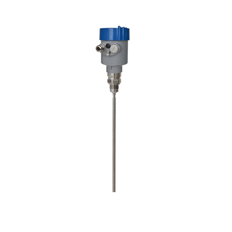
Radar Level Gaugeis an industrial instrument that utilizes the microwave echo ranging principle to achieve non-contact continuous liquid level measurement. It is widely used in industries such as petrochemicals, chemicals, and power, and supports two-wire and four-wire applications....


 Skype
Skype
 whatsapp
 mail
mail