Shandong Fengtu IOT Technology Co., Ltd
Sales Manager:Ms. Emily Wang
Cel,Whatsapp,Wechat:+86 15898932201
Email:info@fengtutec.com
Add:No. 155 Optoelectronic Industry Accelerator, Gaoxin District, Weifang, Shandong, China


Sales Manager:Ms. Emily Wang
Cel,Whatsapp,Wechat:+86 15898932201
Email:info@fengtutec.com
Add:No. 155 Optoelectronic Industry Accelerator, Gaoxin District, Weifang, Shandong, China
time:2026-08-18 09:12:31 source:Weather Station viewed:34 time
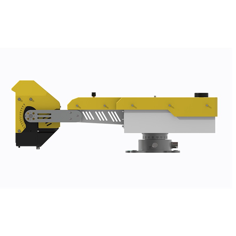
Based on research achievements from Sun Yat-sen University, the intelligent slope monitoring system utilizes arc-shaped synthetic aperture radar (AR) technology to scan slopes for minute deformations over a 360° distance with sub-millimeter precision, operating 24/7. It is suitable for scenarios such as mining, water conservancy, and highways, automatically monitoring and warning of landslide and collapse stability.
Leveraging research from Sun Yat-sen University, the proprietary arc-shaped synthetic aperture radar (AR) intelligent slope monitoring system can combine phase differential interferometry (PDI) technology to extract minute surface deformation and displacement information within the observation area over a long distance, providing stability monitoring services for various geological bodies and major engineering projects. The system covers numerous application scenarios including small and medium-sized open-pit mines, geological hazard points, water conservancy projects, and railways and highways. It can conduct long-term continuous monitoring as well as temporary emergency monitoring after a landslide.
The intelligent slope monitoring system employs an edge computing architecture, integrating positioning, orientation, data processing, and wireless communication functions within the device itself. This eliminates the need for numerous external supporting devices, reducing the difficulty of on-site deployment. The equipment boasts a measurement accuracy of 0.1 mm, capable of capturing early, minute deformations invisible to the naked eye. It has a maximum monitoring distance of 2000 meters, achieving 360-degree wide-area scanning coverage. The scanning cycle is controlled between 0.5 and 4 minutes, allowing for flexible adjustment of the acquisition frequency based on on-site monitoring needs. The equipment itself is highly adaptable to various environments; adverse conditions such as rain, fog, snow, dust, and fire will not interfere with normal monitoring operations. It can operate stably around the clock and in all weather conditions. It can also be mounted on a transport trailer platform for mobile operation, making it suitable for dispersed locations and complex terrain in the field.
This intelligent slope monitoring equipment primarily collects slope surface displacement indicators. The system determines the current stability of the slope using two parameters: the displacement value and the rate of displacement change. When abnormal deformation occurs, it automatically triggers early warning information, helping personnel to address potential landslides and collapses immediately. Currently, the equipment has been put into use for long-term monitoring of slopes in small and medium-sized mines, temporary monitoring of mine landslides, monitoring of geological disaster hazard points, and safety monitoring of tailings dams. The equipment has a resolution of ≤0.3m*10mrad and the monitoring data is highly reliable. It can make up for the shortcomings of traditional manual inspection, limited coverage of single-point sensor monitoring, and inability to operate in severe weather, further improve the technical means of pre-disaster prevention and control of geological disasters, and reduce various losses caused by slope instability accidents.
In coal mining, which is a crucial part of the industry, ensuring operational safety, enhancing productivity and maintaining environmental health are the primary goals. Our micro-weather monitoring equipment provides real-time and accurate weather data monitoring and forecasting services for mining...
Doppler Flow Meter is a dedicated sensor for measuring water flow velocity in natural water bodies. It accurately calculates flow velocity by calculating frequency changes and is widely used in irrigation canals, municipal sewer pipes, and hydrological basins. It is suitable for hydrological m...
The establishment and use of automatic weather station, Windway Technology automatic weather station is a multi-factor weather station, which can operate normally all day long under unattended and harsh environment. It consists of two major parts: data collection system and communication network, wh...
A wind sensor is a sensor device used to measure and record the direction of the wind, usually in the fields of meteorology, environmental monitoring and agriculture. It calculates the wind direction by measuring the wind speed and, based on the principles of hydrodynamics. These sensors usually pro...


 Skype
Skype
 whatsapp
 mail
mail