Shandong Fengtu IOT Technology Co., Ltd
Sales Manager:Ms. Emily Wang
Cel,Whatsapp,Wechat:+86 15898932201
Email:info@fengtutec.com
Add:No. 155 Optoelectronic Industry Accelerator, Gaoxin District, Weifang, Shandong, China


Sales Manager:Ms. Emily Wang
Cel,Whatsapp,Wechat:+86 15898932201
Email:info@fengtutec.com
Add:No. 155 Optoelectronic Industry Accelerator, Gaoxin District, Weifang, Shandong, China
time:2024-12-23 10:27:39 source:Weather Station viewed:1115 time
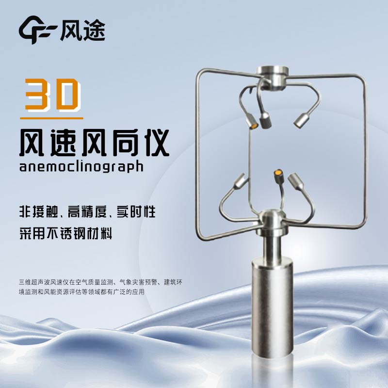
The 2D Ultrasonic Anemometer focuses on measuring the wind speed components and wind directions in two perpendicular directions within a plane (usually the east-west and north-south directions on the horizontal plane), and obtains the resultant wind speed and direction within the plane through trigonometric relationships, mainly reflecting the horizontal wind conditions. On the other hand, the 3D Ultrasonic Anemometer can measure the wind speed components in three mutually perpendicular directions in space, covering both horizontal and vertical directions, with the emphasis on obtaining comprehensive information of complex wind fields.
The 2D Ultrasonic Anemometer is suitable for situations where the vertical wind speed is not highly required, such as the monitoring of ground-level horizontal winds at conventional meteorological observation stations and the monitoring of the horizontal wind field on the sea surface during navigation. The 3D Ultrasonic Anemometer is used in fields such as meteorological convective weather research and wind field monitoring at airports. In these scenarios, the vertical air movement is important for weather systems and flight safety.
Common 2D Ultrasonic Anemometers include combinations of mechanical wind cup anemometers and wind vanes, or two-dimensional ultrasonic anemometers, and their principles are relatively simple and straightforward. The structure of the 3D Ultrasonic Anemometer is more complex. For example, a three-dimensional ultrasonic wind speed and direction anemometer needs to arrange sensor arrays in three coordinate axis directions and calculate wind speed components using the time difference of ultrasonic wave propagation; those based on hot-wire or hot-film technology measure through heat transfer characteristics and operate by arranging sensors in three directions.
The data processing of the 2D Ultrasonic Anemometer is simple, and the accuracy in the horizontal direction can meet conventional requirements, but misjudgments may occur in complex environments. The data processing of the 3D Ultrasonic Anemometer is complex. It can comprehensively reflect the real situation of the wind field, and the measurement accuracy of the wind speed in each direction is higher, especially the improvement in the vertical direction is obvious. However, its accuracy is also affected by factors such as instrument quality and the environment.
Radar water level monitoring station manufacturer - Windway Technology, a domestic manufacturer of radar water level monitoring station, can choose the right products according to different engineering needs in order to meet the needs of different areas of water level observation accuracy and reliab...
Fengtu specializes in the research, development, and production of environmental online monitoring equipment. Its FT-WQX2 Ultrasonic Wind Speed Direction Sensor has been recognized by the market in the field of meteorological monitoring.This device is capable of continuously monitoring outdoor meteo...
A weather station is a commonly used meteorological instrument that provides detailed meteorological data and combines it with specific application scenarios, industries and specific options for the various sensing hardware devices that make it up. This equipment enables the timely and accurate dete...
Real-time automatic weather station equipment, whose main function is to provide meteorological information and observation data. It is a new type of weather monitoring system which has the advantages of fast observation data collection, high accuracy and high reliability. It can be widely used in p...


 Skype
Skype
 whatsapp
 mail
mail