Shandong Fengtu IOT Technology Co., Ltd
Sales Manager:Ms. Emily Wang
Cel,Whatsapp,Wechat:+86 15898932201
Email:info@fengtutec.com
Add:No. 155 Optoelectronic Industry Accelerator, Gaoxin District, Weifang, Shandong, China


Sales Manager:Ms. Emily Wang
Cel,Whatsapp,Wechat:+86 15898932201
Email:info@fengtutec.com
Add:No. 155 Optoelectronic Industry Accelerator, Gaoxin District, Weifang, Shandong, China
time:2024-04-01 09:36:32 source:Weather Station viewed:915 time
Radar is a ground-breaking electronic technology of the 20th century, originating from an early system developed in the United Kingdom in 1935 to defend against airborne threats. Today, the technology has evolved and serves a number of important fields such as aviation, geographic mapping, weather monitoring and marine navigation.
Radar works in a similar way to the eye, but it uses radio waves to detect and measure targets. The word "radar" comes from an acronym that stands for "radio detection and ranging". Although radio waves and light waves are both electromagnetic waves, they exist in different frequency bands. Both travel at the speed of light, but radio waves are particularly suited to radar systems because they can penetrate clouds and other obstacles to detect distant objects.
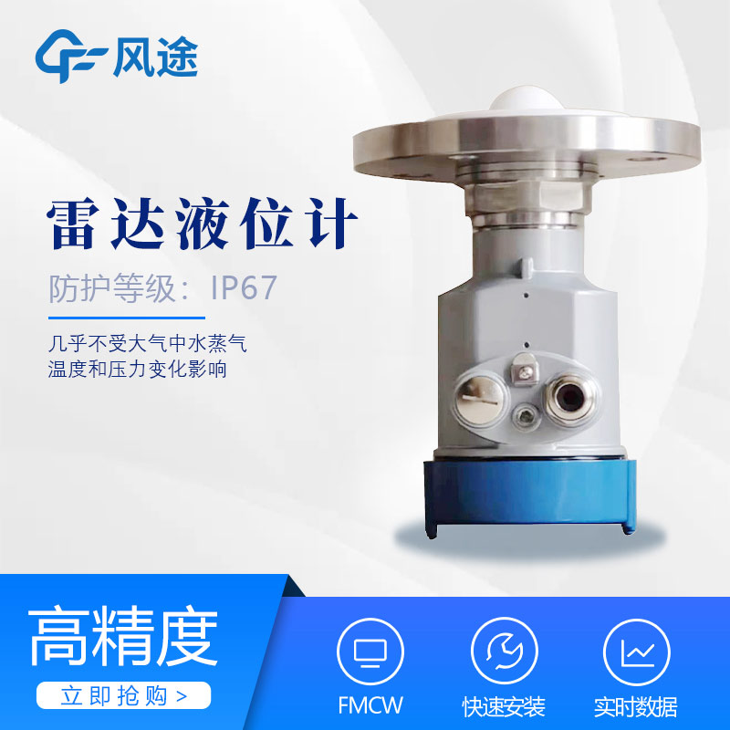
How a radar level gauge works:
It works by emitting electromagnetic waves and receiving signals from these waves as they reflect back from the surface of the liquid. The antenna of the radar level gauge emits electromagnetic pulses and when these pulses meet the surface of the liquid they are reflected and the reflected waves are captured by the same antenna.
By measuring the time it takes for an electromagnetic wave to travel from emission to reception of the return wave, the radar level gauge can calculate the distance from the antenna to the surface of the liquid. This distance is proportional to the speed of propagation of the electromagnetic wave (the speed of light) and the running time, and can be expressed by the formula D = CT/2, where D is the distance, C is the speed of light, and T is the round trip time of the electromagnetic wave.
Since the radar level gauge knows the fixed distance E to the bottom of the empty tank, the height L of the liquid can be obtained by subtracting the distance D from the antenna to the surface of the liquid, i.e. L = E - D. In this way, the radar level gauge can accurately measure and display the current height of the liquid.
Currently there are two main types of radar level gauges: pulsed radar and FM continuous wave radar.
Pulsed radar occupies a central position in the development of radar technology due to its advantages in precise ranging. This type of radar works by transmitting a pulsed signal and waiting for an echo to be reflected back. Since the reception of the echo occurs in the interval between the emission of the pulse, the same antenna can be used for transmission and reception, which simplifies the design of the system. The actual distance measurement is based on the time difference between the transmitted pulse and the received echo pulse. Since electromagnetic waves travel at the speed of light, by measuring this time difference, the exact distance to the target object can be calculated. This method makes pulse radar a very effective tool for distance measurement.
Frequency Modulated Continuous Wave (FMCW) radar works by transmitting a continuous electromagnetic wave with a frequency that increases linearly with time in a specific direction over a set time period, say 50 milliseconds. At the same time, it continuously receives an echo signal from the same direction using another antenna. At any given moment, the difference between the frequency of the echo and the frequency of the transmitted wave is constant, and this frequency difference is proportional to the distance from the target object to the radar station. This property allows the radar to effectively measure the position of the target object.
Water Flow Meter is a general-purpose instrument used in hydrological testing to measure the time-averaged flow velocity at cross-sections of rivers, lakes, reservoirs, and canals. It has a velocity measurement range of 0.04 to 10.00 meters per second, a measurement error of no more than 1.5%,...
Soil is an extremely valuable resource on Earth that supports all terrestrial ecosystems. To make good use of and protect the soil, it is necessary to constantly check its various conditions. This requires the use of advanced measuring tools that can tell us the moisture, temperature and other impor...
Corrosion-resistant radar level gauge is a kind of instrument used to measure the height of liquid level in liquid container. It uses radar technology to send and receive microwave signals to measure the liquid level height by measuring the propagation time of the microwave signals or the echo stren...
Due to the accumulation and fermentation of massive waste, landfill sites continuously generate complex malodorous pollutants. For example, ammonia irritates respiratory mucous membranes, styrene poses a carcinogenic risk, high-concentration hydrogen sulfide can cause human poisoning, and volatile o...


 Skype
Skype
 whatsapp
 mail
mail