Shandong Fengtu IOT Technology Co., Ltd
Sales Manager:Ms. Emily Wang
Cel,Whatsapp,Wechat:+86 15898932201
Email:info@fengtutec.com
Add:No. 155 Optoelectronic Industry Accelerator, Gaoxin District, Weifang, Shandong, China


Sales Manager:Ms. Emily Wang
Cel,Whatsapp,Wechat:+86 15898932201
Email:info@fengtutec.com
Add:No. 155 Optoelectronic Industry Accelerator, Gaoxin District, Weifang, Shandong, China
time:2024-04-23 08:38:15 source:Weather Station viewed:1244 time
In the absence of instrumentation, the moisture condition of the soil can be quickly assessed by hand feel and is usually categorised into the following four classes:
Wet: if water flows out visibly when the soil is squeezed, this indicates high soil moisture.
Wet: Soil that leaves wet marks in the hand and can be easily rolled into clumps or strips, but no water flows out, indicates that the soil is in a moist state.
Slightly moist: Soil that is cool and moist to the touch and leaves a slight indentation when lightly pressed indicates moderately moist soil.
Dry: The soil does not feel cool to the touch and the clay begins to clump and harden, which indicates that the soil is dry.
The general situation of soil drought can be seen without the use of instruments, and specific soil moisture data can be obtained by using instruments, which is easy to analyse.
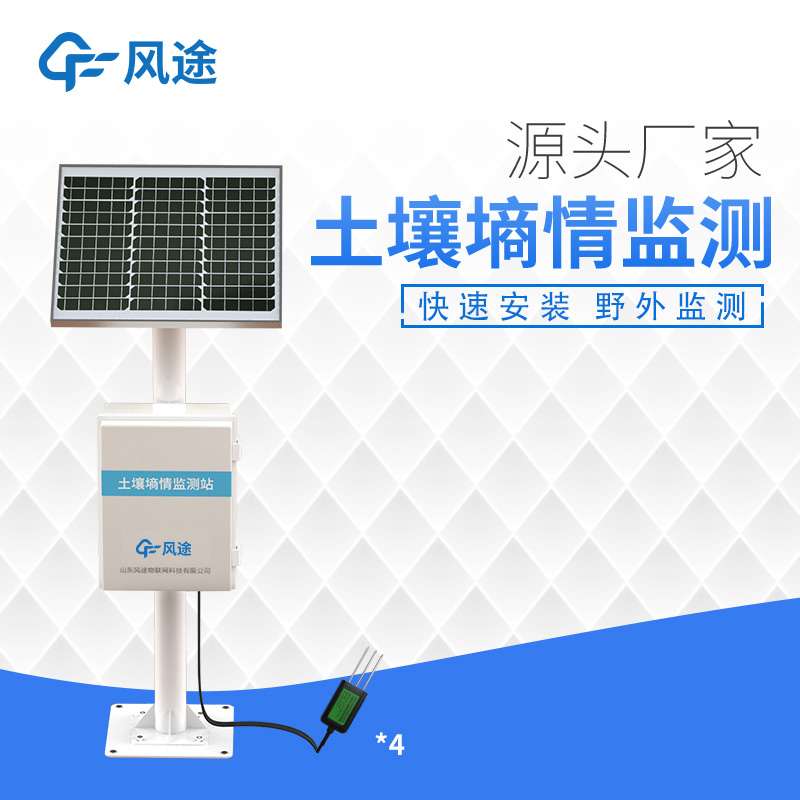
The Automatic Soil Moisture Monitoring System is primarily used to monitor the moisture content and temperature of the soil. The system consists of the following core components:
Data Acquisition Module: collects soil volumetric water content (VWC) and temperature data through sensors installed in the soil.
Data transmission module: transmits the collected data to the central database via wireless or wired means.
Database: Stores monitoring data to ensure data uniformity and traceability.
The system can be expanded according to user requirements by adding sensors for air temperature and humidity, soil conductivity, solar radiation, carbon dioxide and other meteorological parameters to provide more comprehensive monitoring data. The monitoring station automatically sends the data to the network data platform and stores it in a standardised format. Users can view the data in an intuitive way such as graphs and charts for easy understanding and analysis.
The system architecture includes:
Sensing layer: the sensor layer in direct contact with the soil, responsible for collecting soil and meteorological data.
Transmission layer: responsible for transmitting the data collected by the sensing layer to the data processing centre.
Data layer: a database system that processes and stores the data coming from the transmission layer.
Service layer: provides data processing, analysis and visualisation services.
Application layer: final user interface, providing data access, monitoring and management functions.
Standard Specification and Operation Guarantee System: Ensures standardised operation and maintenance of the system.
This system provides accurate soil moisture and temperature information for agriculture through automated and intelligent means, supporting scientific irrigation and farming decisions.
The GNSS Monitoring Station can detect potential dangers in a timely manner by monitoring mountain displacements with high precision. It can collect the three-dimensional coordinates of monitoring points on the mountain surface in real time, with an accuracy reaching the centimeter or even millimete...
liquid sensor is used to monitor the liquid level in industrial production, aquarium, chemical liquid and other containers....
Carbon monoxide and nitrogen dioxide gases in mines pose great hazards to the safety of miners' lives and mine operations, which is the main reason for their monitoring.Carbon monoxide is a colorless, odorless, and tasteless gas. Its affinity for human hemoglobin is 200 - 300 times higher than t...
In the third-party pollution control of industrial parks, "monitoring" is a core link. However, scattered monitoring points face problems such as high operation and maintenance costs and difficulty in unified management. Atmospheric pollution grid monitoring technology, which combines &quo...


 Skype
Skype
 whatsapp
 mail
mail