Shandong Fengtu IOT Technology Co., Ltd
Sales Manager:Ms. Emily Wang
Cel,Whatsapp,Wechat:+86 15898932201
Email:info@fengtutec.com
Add:No. 155 Optoelectronic Industry Accelerator, Gaoxin District, Weifang, Shandong, China


Sales Manager:Ms. Emily Wang
Cel,Whatsapp,Wechat:+86 15898932201
Email:info@fengtutec.com
Add:No. 155 Optoelectronic Industry Accelerator, Gaoxin District, Weifang, Shandong, China
time:2024-06-11 08:47:41 source:Weather Station viewed:971 time
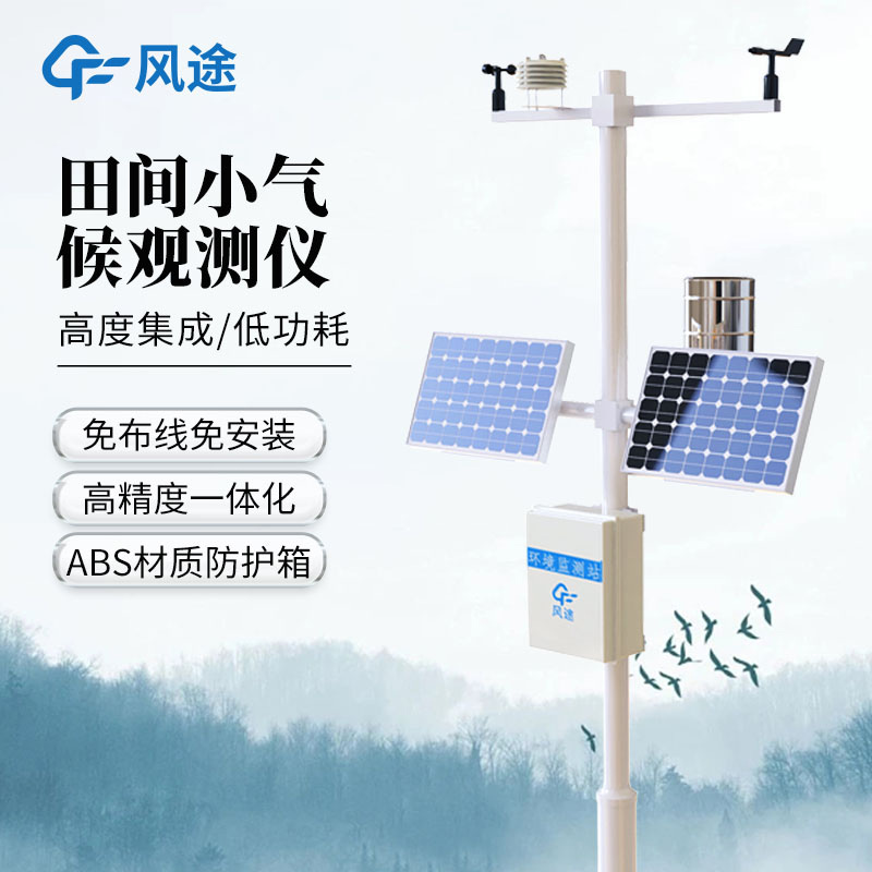
Deploying field intelligent meteorological observation stations in agricultural areas to build a meteorological monitoring network covering the entire region and accurate to the kilometre level allows for continuous intelligent monitoring of soil moisture and climatic conditions. By analysing the key meteorological factors affecting crop growth and targeting the various critical stages of crop growth, precise meteorological forecasting and monitoring services can be provided. Such services can effectively support agricultural production, ensure healthy crop growth and improve agricultural yields and quality.
In the past, farmers relied on watching the sky to decide on farming activities, but now they rely on data to guide their decisions. Using automated weather stations, we are able to monitor light, air temperature and soil temperature and humidity conditions in real time. Once the temperature at a depth of 5 cm in the soil tillage layer has stabilised above 5 degrees Celsius, the management area is able to quickly initiate planting to ensure that the optimal farming time is not missed. This data-based approach to precision agriculture management helps farmers organise their farming activities more efficiently, improving the quality and efficiency of their crops.
In traditional agriculture, farmers need to personally go to the field to observe crop growth, but now, with the application of information technology, they can monitor the growth of crops in real time through mobile phone applications without leaving their homes. These intelligent systems not only provide crop growth information, but also send timely notifications of agricultural activities such as pest removal and fertiliser application, greatly reducing the labour intensity of farmers.
Through the smart screen set up in the village square, the village committee is also able to know the specific conditions of the farmland in real time. Once any problems are monitored, such as weather changes or the occurrence of pests and diseases, the village committee can quickly notify farmers to take measures, which not only improves the speed of response, but also strengthens the safety of farmland management.
In short, modern information technology means provide a double guarantee for farmland management, making agricultural production more intelligent and efficient.
Outdoor adventure activities such as camping, mountaineering, hiking and fishing have become popular choices for modern urbanites to pursue nature and relax. It is crucial to know the weather conditions of your destination before you set off, but traditional weather forecasts often have wide coverag...
Sensors used to detect the amount of rainfall include "resistance sensors", "piezoelectric sensors", and "photoelectric sensors".Principle of Piezoelectric Rain SensorPiezoelectric rain sensors utilize the impact measurement principle to measure the weight of individual...
Oilseed rape is an important cash crop in the south. Using agricultural meteorological observation data, we can count the important meteorological elements affecting the growth of oilseed rape, mainly including light, precipitation and temperature, etc. Through trend prediction of climate, we can re...
Ground-based multi-element automatic weather stations are the basic facilities to achieve large scale, long time continuous observation. With the rapid development of computer technology and communication network technology, it needs to be modified and upgraded in order to improve the data processin...


 Skype
Skype
 whatsapp
 mail
mail