Shandong Fengtu IOT Technology Co., Ltd
Sales Manager:Ms. Emily Wang
Cel,Whatsapp,Wechat:+86 15898932201
Email:info@fengtutec.com
Add:No. 155 Optoelectronic Industry Accelerator, Gaoxin District, Weifang, Shandong, China


Sales Manager:Ms. Emily Wang
Cel,Whatsapp,Wechat:+86 15898932201
Email:info@fengtutec.com
Add:No. 155 Optoelectronic Industry Accelerator, Gaoxin District, Weifang, Shandong, China
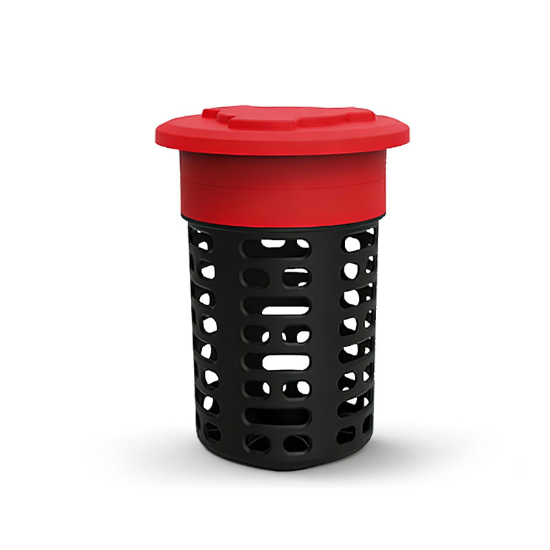
Model:FT-BY2L
Brand:fengtu
1、Termite Baiting Systems Product Applications
Termite Baiting Systems can realize remote monitoring and intelligent management of termites by installing monitoring devices and using network data interaction for real-time monitoring and management.This product provides real-time monitoring of termite activity, enabling early warning and precise detection. It also records and analyzes data, supports remote monitoring, allowing managers to stay informed at all times. Furthermore, it can be used to evaluate the effectiveness of control measures, providing strong support for scientific termite control. It is widely used in water conservancy dams, building construction, historical building preservation, and landscaping.
2、Termite Baiting Systems Product Features
This system utilizes a comprehensive approach combining loop technology, proprietary network communication technology, and internet technology, resulting in a highly sensitive termite monitoring and early warning system.
Unlike traditional monitoring devices that require manual inspection, this system features non-invasive automatic termite detection, automatically uploading detection results daily. The backend management platform immediately displays the detection results.
The monitoring accuracy rate exceeds 95%.
All components are modular in design, allowing for independent operation and easy replacement of individual parts during operation.
The monitoring device's casing and internal frame are made of a composite resin-nylon material, and the sensing electronic module is sealed to IP68 standards. This provides excellent corrosion resistance, ensuring reliable operation in various soil environments, including humid and acidic conditions.
3、Termite Baiting Systems System Components
The system consists of several parts: a monitoring device housing module, a lure and triggering module, a signal acquisition module, an information processing and transmission module, a database, PC-based management software, and a WeChat mini-program.
4、Termite Baiting Systems Device Analysis
Information Box: IP68 rated encapsulated circuit board
Information Stick: Termite information collection wood made from pine wood.
Carbon Wire: Waterproof carbon material coated onto the information stick. When termites gnaw on the wood, they corrode the information stick, triggering an alarm.
5、Termite Baiting Systems Technical Specifications
Communication Module: LoRa
Dimensions: 14cm x 14cm x 22cm
Inner Core Material: Dried pine wood, drying grade 1, 12 pieces of pine wood per device
Outer Casing Material: Anti-aging and environmentally friendly material, top cover with locking function and anti-theft design
Operating Temperature: -20°C to 80°C
Operating Humidity: >80%
Monitoring and Alarm Accuracy Rate: ≥95%
Monitoring False Alarm Rate: <5%
Outer Casing UV Aging Resistance: ≥Grade 4
Outer Casing Tensile Strength: ≥80MPa
Outer Casing Bending Strength: ≥100MPa
Outer Casing Impact Strength: ≥15KJ/㎡
Protection Rating: IP68
Battery Life: ≥5 years
A large number of industrial enterprises are concentrated in industrial parks. Industrial production activities will inevitably affect the surrounding air quality. To supervise and improve air quality, it is necessary to deploy Air Quality Monitoring Stations in the parks.An Air Quality Monitoring S...
A meteorological sensor is a device used to measure and monitor atmospheric environmental parameters, primarily to obtain meteorological data and convert it into electrical signals for data processing and storage. Meteorological sensors usually include components such as sensors and signal conversio...
The GNSS monitoring station determines the three-dimensional spatial position (longitude, latitude and elevation) of the monitoring point based on the satellite signals of the Beidou Satellite Navigation System (BDS) and the Global Navigation Satellite System (GNSS). By receiving the signals transmi...
In many fields such as water conservancy, fishery, and navigation, accurately measuring water depth is a fundamental and crucial task. Whether it's the maintenance of waterways, the monitoring of reservoirs, or the control of the aquaculture environment, water depth data plays an indispensable r...


 Get a Free Quote
 Skype
 whatsapp
 mail