Shandong Fengtu IOT Technology Co., Ltd
Sales Manager:Ms. Emily Wang
Cel,Whatsapp,Wechat:+86 15898932201
Email:info@fengtutec.com
Add:No. 155 Optoelectronic Industry Accelerator, Gaoxin District, Weifang, Shandong, China


Sales Manager:Ms. Emily Wang
Cel,Whatsapp,Wechat:+86 15898932201
Email:info@fengtutec.com
Add:No. 155 Optoelectronic Industry Accelerator, Gaoxin District, Weifang, Shandong, China
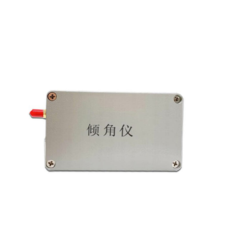
Model:FT-QJ1
Brand:fengtu
1.Wireless Tilt Sensor Product Introduction
Wireless Tilt Sensor is a device for remote real-time monitoring and analysis of physical characteristics such as geological inhomogeneous settlement and tilt deformation.Our company designs and develops inclinometers based on the principles of high precision, low power consumption, stability and reliability. It can be combined with intelligent gateways, alarm equipment and the Internet of Things platform to form a closed-loop system of geological disaster risk points, self-monitoring, self-analysis and self-alarm. It is suitable for monitoring fields such as geological disasters, geotechnical engineering, construction engineering, transportation, water conservancy, and municipal administration, and is aimed at real-time monitoring of high-frequency vibration of structures and micro-tilt changes of geological disaster bodies.
2. Wireless Tilt Sensor Product Features
(1) High integration: The MEMS acceleration module is integrated to realize the three-axis acceleration and three-axis inclination observation functions, and the ambient temperature is collected for temperature compensation;
(2) Multi-communication: Integrates 2/4G full-network public network communication, supports NB-IoT narrowband Internet of Things communication, and supports LoRa local area self-organizing network communication, realizing local area networking of monitoring equipment, regional release of early warning information, remote transmission of monitoring data, and remote control of equipment;
(3) Low power consumption: Adhering to the design concept of high integration and low power consumption, it realizes the integrated design of sensing, collection and communication. The standby performance meets the needs of long-term use in the field and has the characteristics of easy installation, which is particularly suitable for emergency monitoring deployment;
(4) High precision: Using redundant on-site observations, based on a priori mean error and measured mean error, embedded edge computing and data filtering and data cleaning algorithms, gross error elimination and anomaly detection are achieved to ensure the reliability of monitoring data and meet the requirements of relevant technical standards;
3. Wireless Tilt Sensor Technical Parameters
| Sensor Performance | inclination | Range | ±90° |
| Accuracy | Accuracy: ±0.001/±0.005/±0.01 optional | ||
| Acceleration | Range | ±3g | |
| Accuracy | 0.5mg | ||
| Working conditions | Operating voltage | 3.7V~4.2V | |
| Rated power consumption | <120mA/3.7V | ||
| Operating temperature | -40℃~85℃ | ||
| Operating humidity | 95%RH without condensation | ||
| Communication performance | Communication Network | 2~4GPRS/NB-IOT/LORA | |
| Collection interval | 1~50Hz high frequency or 0~7200s low frequency can be set as needed | ||
| Upload strategy | Scheduled upload + event-triggered upload | ||
| Interactive Control | support | ||
Mobile visibility monitoring stations are used to monitor the visibility values in the air and their change process automatically by various meteorological detection equipment in urban areas, providing a scientific basis for meteorological departments to make decisions on defence against weather dis...
With the development of meteorological technology, the role of meteorological stations in disaster prevention and mitigation is becoming more and more important. Weather stations can monitor multiple meteorological elements, which greatly enhances the monitoring and warning capability of catastrophi...
Traditionally, wind speed and direction measurements have relied on mechanical anemometers, but with the development of ultrasonic technology, people have begun to explore its application in wind speed measurements.The Ultrasonic Anemometer utilizes the properties of ultrasonic waves propagating thr...
Preface.The ultrasonic wind measurement technique uses ultrasound to detect wind speed and direction and has no moving parts compared to older anemometers, so rapid changes in wind speed, especially gusts and wind fluctuations, can be measured more accurately. This technique provides a more reliable...


 Get a Free Quote
 Skype
Skype
 whatsapp
 mail
mail