Shandong Fengtu IOT Technology Co., Ltd
Sales Manager:Ms. Emily Wang
Cel,Whatsapp,Wechat:+86 15898932201
Email:info@fengtutec.com
Add:No. 155 Optoelectronic Industry Accelerator, Gaoxin District, Weifang, Shandong, China


Sales Manager:Ms. Emily Wang
Cel,Whatsapp,Wechat:+86 15898932201
Email:info@fengtutec.com
Add:No. 155 Optoelectronic Industry Accelerator, Gaoxin District, Weifang, Shandong, China
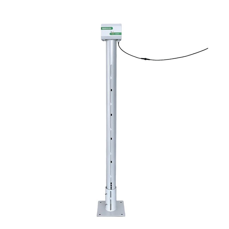
Model:FT-DTS2
Brand:fengtu
Paddy Field Water Level Gauge Practical Significance:
Paddy Field Water Level Gauge based on the principle of micro-power radar measurement, it monitors paddy field water levels in real time and transmits data remotely; featuring a built-in solar power system, it is suitable for long-term outdoor use.In the context of paddy field water level monitoring, the Paddy Field Water Level Gauge resolves common issues such as the susceptibility of submersible level sensors to clogging by mud and silt, and the interference caused by rice foliage to ultrasonic or radar level sensors. Additionally, the Paddy Field Water Level Gauge is lightweight, portable, and easy to install, making it ideal for mobile, multi-point monitoring across paddy fields; it is a water level measurement device specifically optimized for this application.
Furthermore, the Paddy Field Water Level Gauge utilizes standard communication interfaces to link with integrated gate control systems, enabling automated, precision management of paddy field water levels. Supported by our company’s complimentary cloud services and mobile app, it facilitates a range of IoT-enabled functions—including remote online monitoring, data logging, trend analysis, and remote alerts—thereby ensuring scientifically managed rice cultivation and the efficient use of water resources.
Paddy Field Water Level Gauge System Structure:
The unit consists of an integrated solar-powered main control housing, an antenna, a support pole, a mounting base, and ground anchors. Constructed from powder-coated stainless steel, the device is immune to rust-related damage and is designed for year-round installation in paddy fields.
Main Control Housing: Features an IP68 protection rating (waterproof, dustproof, and corrosion-resistant) and a built-in high-capacity lithium battery; the integrated solar design eliminates the need for an external power supply system.
Support Pole: Utilizes a "hollow conductive channel" design that provides a compact RF structure for radar sensing; this design avoids external interference with the radar signal while ensuring water circulation between the inside and outside of the pole.
Mounting Base: Secured via ground anchors for easy installation, making the device suitable for mobile, multi-point monitoring in paddy fields; it also ensures a stable baseline reference for radar measurements, resulting in higher accuracy for water level readings.
Measurement Method: Radar sensing;
Paddy Field Water Level Gauge Measured parameters:
4G: Supports networked monitoring of parameters such as paddy field water level (air gap distance and actual level), remaining battery power, and solar charging status;
Average power consumption: 0.6W.
Communication interfaces: RS485, 4G, NB-IoT, LoRa;
Measurement range: Selectable ranges of 0–1m, 0–2m, or 0–3m;
Typical accuracy: ±1mm
Resolution: 1mm
Data upload frequency: Default 60 min/transmission (battery-powered model), configurable;
Data acquisition frequency: Default 3600 s/reading (battery-powered model), configurable;
Ingress protection rating: IP68
Operating environment: -20°C to +60°C, 0% RH to 99% RH (non-condensing).
Chloride Ion Sensor relies on the principle of ion selection to measure the concentration of free chloride ions in water in real time, with a range of 0-3500.0 mg/L. It features RS-485 (MODBUS-RTU) signal output, offering rapid and economical detection, and is suitable for online chloride ion...
The IV curve is a crucial indicator of photovoltaic (PV) string performance. By measuring the current through the string at different voltages, a relationship curve between current and voltage—i.e., the IV curve—is plotted. Analyzing the IV curve can reveal various issues in the PV string, such as...
Boat Depth Finder automatically calculates water depth data by transmitting and receiving acoustic signals via an ultrasonic transducer. The device simultaneously displays water temperature, latitude and longitude coordinates, travel speed, time and date, and Bluetooth connection status....
Industrial Weather Station is specifically designed for flammable and explosive environments such as chemical plants and oil depots. It integrates wind speed, wind direction, temperature, humidity, and atmospheric pressure monitoring, employing high-level explosion-proof and corrosion-resistan...


 Get a Free Quote
 Skype
Skype
 whatsapp
 mail
mail