Shandong Fengtu IOT Technology Co., Ltd
Sales Manager:Ms. Emily Wang
Cel,Whatsapp,Wechat:+86 15898932201
Email:info@fengtutec.com
Add:No. 155 Optoelectronic Industry Accelerator, Gaoxin District, Weifang, Shandong, China


Sales Manager:Ms. Emily Wang
Cel,Whatsapp,Wechat:+86 15898932201
Email:info@fengtutec.com
Add:No. 155 Optoelectronic Industry Accelerator, Gaoxin District, Weifang, Shandong, China
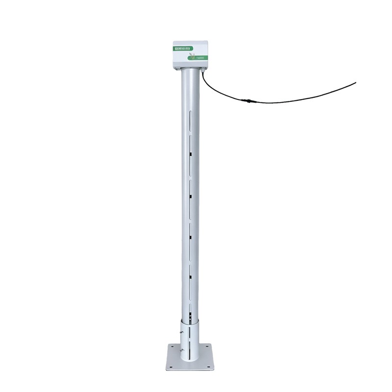
Model:FT-DTS1
Brand:fengtu
Rice Field Water Level Gauge Practical Significance:
Rice Field Water Level Gauge is a device designed to monitor water levels in rice fields. Utilizing low-power radar measurement technology, it measures the water level in real-time to ensure it remains within the optimal range.In the context of paddy field water level monitoring, the Rice Field Water Level Gauge resolves common issues such as the susceptibility of submersible level sensors to clogging by mud and silt, and the interference caused by rice foliage to ultrasonic or radar level sensors. Additionally, the Rice Field Water Level Gauge is lightweight, portable, and easy to install, making it ideal for mobile, multi-point monitoring across paddy fields; it is a water level measurement device specifically optimized for this application.
Furthermore, the Rice Field Water Level Gauge utilizes standard communication interfaces to link with integrated gate control systems, enabling automated, precision management of paddy field water levels. Supported by our company’s complimentary cloud services and mobile app, it facilitates a range of IoT-enabled functions—including remote online monitoring, data logging, trend analysis, and remote alerts—thereby ensuring scientifically managed rice cultivation and the efficient use of water resources.
Rice Field Water Level Gauge System Structure:
The unit consists of an integrated solar-powered main control housing, an antenna, a support pole, a mounting base, and ground anchors. Constructed from powder-coated stainless steel, the device is immune to rust-related damage and is designed for year-round installation in paddy fields.
Main Control Housing: Features an IP68 protection rating (waterproof, dustproof, and corrosion-resistant) and a built-in high-capacity lithium battery; the integrated solar design eliminates the need for an external power supply system.
Support Pole: Utilizes a "hollow conductive channel" design that provides a compact RF structure for radar sensing; this design avoids external interference with the radar signal while ensuring water circulation between the inside and outside of the pole.
Mounting Base: Secured via ground anchors for easy installation, making the device suitable for mobile, multi-point monitoring in paddy fields; it also ensures a stable baseline reference for radar measurements, resulting in higher accuracy for water level readings.
Measurement Method: Radar sensing;
Rice Field Water Level Gauge Measured Parameters:
RS485 Model: Supports networked monitoring of parameters such as paddy water level (air gap distance), actual water level, remaining battery power, and solar charging status.
Power Supply Range:
RS485 Model: 10–30 V DC.
Average Power Consumption: 0.6 W.
Communication Interfaces: RS485, 4G, NB-IoT, LoRa.
Measurement Range: Selectable ranges of 0–1 m, 0–2 m, or 0–3 m.
Typical Accuracy: ±1 mm.
Resolution: 1 mm.
Data Upload Frequency: Default 60 min/interval (battery-powered version); configurable.
Data Acquisition Frequency: Default 3600 s/interval (battery-powered version); configurable.
Ingress Protection: IP68.
Operating Environment: -20°C to +60°C; 0% RH to 99% RH (non-condensing).
Soil is the foundation for crop growth, providing crops with growth factors such as water, nutrients, air and heat. The properties and quality of soil are influenced by a number of factors, including its original geological composition (parent material), climate, biological activity, topography and...
Traditional anemometers such as mechanical wind speed meters and cup anemometers rely on the rotation or swing of mechanical components like wind cups and vanes to sense wind speed and direction, presenting multiple limitations:Mechanical Wear & High Maintenance: Long-term use leads to friction...
For a long time, visibility observation has often relied on manual visual estimation, which is subjective and has a large margin of error. With the rapid advancement of photoelectric instruments, manual estimation has gradually been replaced by Visibility meters that can operate around the clock. Cu...
The automatic agricultural weather station is capable of automatic sensing, monitoring, warning and analysis of weather, moisture, soil and crop growth, and is so systematic that it achieves intelligent seedling, precision sowing, precision fertilisation, precision irrigation, precision spraying and...


 Get a Free Quote

 Skype
 whatsapp
 mail