Shandong Fengtu IOT Technology Co., Ltd
Sales Manager:Ms. Emily Wang
Cel,Whatsapp,Wechat:+86 15898932201
Email:info@fengtutec.com
Add:No. 155 Optoelectronic Industry Accelerator, Gaoxin District, Weifang, Shandong, China


Sales Manager:Ms. Emily Wang
Cel,Whatsapp,Wechat:+86 15898932201
Email:info@fengtutec.com
Add:No. 155 Optoelectronic Industry Accelerator, Gaoxin District, Weifang, Shandong, China
time:2024-12-31 10:39:55 source:Weather Station viewed:757 time
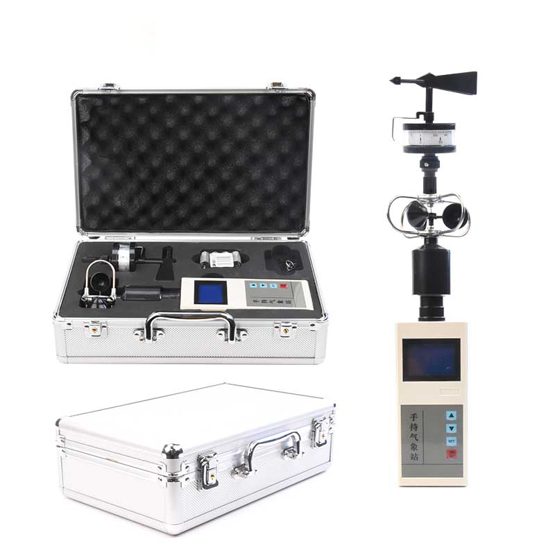
1.Product introduction of the best anemometers in the world
the best anemometers in the world is a handheld and portable anemometer used to accurately measure wind speed.The best anemometers in the world is a portable meteorological observation instrument that is easy to carry, simple to operate and integrates multiple meteorological elements.The system uses precision sensors and smart chips to accurately measure two meteorological elements, wind direction and wind speed, at the same time.The built-in large-capacity FLASH memory chip can store at least one year of meteorological data; the universal USB communication interface can be connected to a U disk to export data, which facilitates users to further process and analyze meteorological data.
The best anemometers in the world can be widely used in meteorology, environmental protection, airports, agriculture and forestry, hydrology, military, warehousing, scientific research and other fields.
2.Features of the best anemometers in the world
2.1-inch screen LCD displays temperature and wind speed;
Special wind direction dial (16 directions) and pointer are used to indicate real-time wind direction;
Large-capacity data storage, which can store up to 40,000 pieces of meteorological data (the data recording interval can be set between 1 and 60 minutes);
Universal USB communication interface, convenient for USB data downloading;
Only three AA dry batteries are needed for power supply; low power consumption design, long-term standby;
The structural design is scientific and reasonable, and it is easy to carry.
3.Technical parameters of the best anemometers in the world
| Meteorological parameters | Measurement elements | Measuring range | Accuracy | resolution | unit |
| wind speed | 0~30 | ±0.3 | 0.01 | m/s | |
| wind direction | 16 directions | ±1 bearing | 1 direction | position | |
| power supply | AA dry cell battery (3 pieces) | ||||
| communication | USB | ||||
| storage | 40,000 pieces of data | ||||
| Host size | 160mm×70mm×28mm | ||||
| Overall machine size | 405mm×100mm×100mm | ||||
| weight | About 0.5Kg | ||||
| working environment | -20℃~80℃; 5%RH~95%RH | ||||
4.Precautions for using the best anemometers in the world
1.It is recommended to clear the data storage every time you need to record time when you turn on the computer to prevent the large amount of data when exporting the currently required data, which will cause the time to be too long.
2.It is recommended to export the data content in the weather station in time after use.
3.Please read this manual carefully before use and ensure that the sensor is inserted into the corresponding sensor interface and the battery direction is correct;
4.When the instrument shows that the battery power is low, please replace the battery in time to prevent battery leakage and damage to the instrument;
5.Prevent chemical reagents, oil, dust, etc.from directly damaging the sensor.Do not use it for a long time in condensation or extreme temperature environments.Do not subject it to cold or thermal shock;
6.The instrument is a precision device.Users should not disassemble it by themselves during use to avoid damaging the product;
7.Please keep the calibration certificate and certificate of conformity and return them with the product during maintenance.
The GNSS displacement monitoring station is a device that utilizes Global Navigation Satellite System (GNSS) technology and is specifically designed for surface displacement monitoring. It receives satellite signals and accurately monitors the slightest changes in the target position. It is widely u...
With the intensification of global climate change, climate anomalies are frequent, and extreme weather events such as heavy rainfall and flooding occur from time to time, posing great challenges to the construction and development of cities and villages. Under such circumstances, the protection of t...
Road surface condition data is one of the most important parameters of concern for traffic safety, apart from visibility. Whether there is water on the road surface. Snow, ice and other road conditions are one of the safety hazards alerted to. FT-LM2 non-contact road condition detector uses remote s...
Radar Level Gaugeis an industrial instrument that utilizes the microwave echo ranging principle to achieve non-contact continuous liquid level measurement. It is widely used in industries such as petrochemicals, chemicals, and power, and supports two-wire and four-wire applications....


 Skype
Skype
 whatsapp
 mail
mail