Shandong Fengtu IOT Technology Co., Ltd
Sales Manager:Ms. Emily Wang
Cel,Whatsapp,Wechat:+86 15898932201
Email:info@fengtutec.com
Add:No. 155 Optoelectronic Industry Accelerator, Gaoxin District, Weifang, Shandong, China


Sales Manager:Ms. Emily Wang
Cel,Whatsapp,Wechat:+86 15898932201
Email:info@fengtutec.com
Add:No. 155 Optoelectronic Industry Accelerator, Gaoxin District, Weifang, Shandong, China
time:2025-12-29 09:35:29 source:Weather Station viewed:525 time
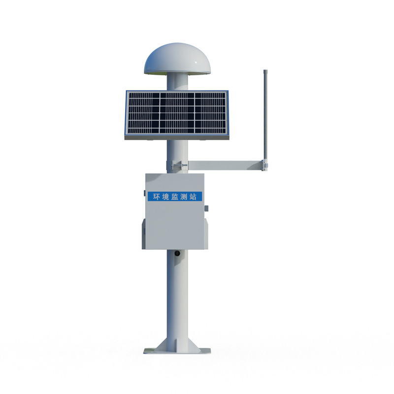
GNSS surface displacement monitoring instrument is a device that utilizes high-precision satellite navigation systems and differential RTK technology to achieve millimeter-level displacement monitoring. It features all-weather real-time monitoring capabilities and is specifically designed for surface displacement and building deformation monitoring, widely used in engineering safety fields such as dams, bridges, and landslides.
GNSS surface displacement monitoring instrument is a professional device that uses Global Navigation Satellite System (GNSS) technology to measure minute displacement changes of the ground surface or structures. The core function of this device is to continuously and automatically acquire the three-dimensional coordinate changes of monitoring points, with an accuracy of up to millimeters, thus achieving high-frequency deformation monitoring.
Its high-precision measurement is mainly achieved through differential RTK technology. This technology involves installing a GNSS receiver at a base station with known precise coordinates and performing real-time data communication and joint calculation with a mobile receiver at the monitoring station. This processing method effectively eliminates common errors such as satellite orbit errors, clock errors, and atmospheric delays, thereby greatly improving the accuracy of relative position measurements and meeting the stringent data accuracy requirements of engineering safety monitoring.
A complete monitoring system typically consists of three parts: a base station installed in a stable location, monitoring stations deployed on the monitoring target, and a back-end central data processing and analysis platform. The monitoring stations and base station simultaneously receive multi-frequency, multi-system satellite signals and transmit the observation data to the data processing center in real time via a wireless network. The software platform automatically processes, analyzes, and stores the data, and can trigger warning messages based on preset thresholds, achieving fully automated management from data acquisition to intelligent early warning.
The application areas of this equipment are mainly concentrated in engineering scenarios closely related to geological and structural safety. In geological disaster prevention, it is a key technological means for automated monitoring and early warning of potential hazards such as landslides, collapses, and mining subsidence, capable of capturing early deformation signs before a disaster occurs. In the field of structural health monitoring of major engineering projects, it is used for dam displacement monitoring, static and dynamic deflection and displacement monitoring of large bridges, high-rise building sway monitoring, and tunnel convergence monitoring. In addition, this equipment also plays an important role in mining subsidence monitoring, tailings dam safety monitoring, and road and railway subgrade stability assessment. The main advantage of GNSS surface displacement monitoring instrument lies in its all-weather, 24/7 operational capability, unaffected by lighting and weather conditions. It can provide absolute three-dimensional displacement data, and line-of-sight between monitoring points is not required, greatly simplifying field deployment. Through continuous 24/7 observation, the system can establish a complete displacement time series curve, helping engineers analyze deformation trends, rates, and patterns, providing direct data for assessing structural safety, developing maintenance measures, and warning of potential risks. With the improvement of satellite systems such as Beidou and the development of chip technology, this type of monitoring equipment is becoming more precise, reliable, and cost-effective, and its application in infrastructure safety and geological disaster early warning will become even more widespread.
The field microclimate observer, also known as an agricultural weather station, is an instrument that provides refined agricultural weather services. Installed in a farming area or greenhouse, the device measures weather parameters such as temperature, humidity, light, rainfall, air pressure, wind s...
The Ultrasonic Wind Velocity and Direction Meter is a modern wind measurement device whose main purpose is to measure wind speed and direction. It uses ultrasonic technology to accurately measure wind speed and direction, and also has the advantages of fast response, no calibration and easy installa...
Hydrological station, is an important part of the water measurement and reporting. It plays an irreplaceable role in hydrological forecasting, and it provides the basis for policy formulation. It can both timely and accurate reflection of river water level changes, but also for the analysis of hydro...
The safety level of slope engineering is divided into first, second, and third levels according to factors such as damage consequences, types, and heights. The monitoring section is often selected at geologically weak or representative locations.The layout of monitoring points for slope automation m...


 Skype
Skype
 whatsapp
 mail
mail