Shandong Fengtu IOT Technology Co., Ltd
Sales Manager:Ms. Emily Wang
Cel,Whatsapp,Wechat:+86 15898932201
Email:info@fengtutec.com
Add:No. 155 Optoelectronic Industry Accelerator, Gaoxin District, Weifang, Shandong, China


Sales Manager:Ms. Emily Wang
Cel,Whatsapp,Wechat:+86 15898932201
Email:info@fengtutec.com
Add:No. 155 Optoelectronic Industry Accelerator, Gaoxin District, Weifang, Shandong, China
time:2025-12-01 09:53:37 source:Weather Station viewed:409 time
GNSS receiver price varies significantly depending on the model and features. The high-precision choke coil antenna version costs approximately 6900 yuan. The device fully supports the Beidou satellite navigation system, integrates differential RTK technology, boasts millimeter-level positioning accuracy, and an IP68 protection rating, making it suitable for surveying, disaster prevention, and transportation applications.
GNSS receivers, as core equipment in modern navigation and positioning technology, have prices significantly affected by their functional configuration and accuracy level. Taking common market models as an example, a high-precision sensor version equipped with a choke coil antenna can cost up to 6900 yuan. This price difference mainly stems from the suitability of hardware performance to application scenarios – the choke coil antenna combined with magnetic wave-absorbing materials effectively suppresses multipath effects, improving positioning stability in complex environments.
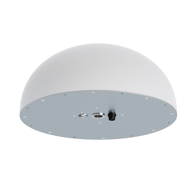
In terms of technical characteristics, modern GNSS receivers have achieved multi-system compatibility, especially full support for the Beidou satellite navigation system. The physical design of the equipment shows a trend towards miniaturization and high durability. The compact structure of the Fengtu Technology model, with a diameter of 360mm and a height of 163mm, reflects the concept of space optimization. At the same time, the IP68 protection rating has become an industry standard, allowing the device to withstand water rinsing and adapt to extreme temperatures from -40°C to 85°C, ensuring long-term stable operation in the field.
Power consumption control and power supply flexibility are another key advantage. Most GNSS receivers maintain power consumption in the 0.25W-3.5W range, supporting DC 10V-15V wide voltage input or 12-58V wide voltage power supply, meeting the needs of unattended monitoring.
High-precision positioning relies on differential RTK technology, with static measurement accuracy reaching ±2.5mm+1ppm horizontally and ±5mm+1ppm vertically. During installation, the baseline distance principle should be followed; a distance of less than 500 meters between the base station and the measurement station is recommended, while avoiding obstruction by tall buildings to ensure satellite signal quality. Some models support the Modbus-RTU communication protocol and offline processing functions, allowing for direct output of horizontal and vertical displacement data.
These devices have been widely used in geological disaster early warning, bridge health monitoring, and precision agriculture. For example, the Fengtu Technology GNSS integrated machine provides millimeter-level displacement change data for dam safety monitoring through its real-time data transmission capabilities. With the full support of the BeiDou-3 signal, future GNSS receivers will continue to optimize in terms of positioning speed and fix rate, providing more reliable support for high-precision applications.
Ultrasonic wind speed and direction sensors work by measuring the difference in propagation time of ultrasonic waves in different directions to determine wind speed and direction. Specifically:Ultrasonic waves have different propagation times in the downwind and upwind directions. When the wind is b...
Wind Speed Gauge utilizes an integrated two-parameter sensor to provide all-weather monitoring of wind speed and direction data. The device detects airflow conditions by emitting continuous, variable-frequency ultrasonic signals and measuring the resulting relative phase shifts. It offers a wi...
A good atmospheric visibility meter should be able to provide accurate measurement data and stable operation even under adverse weather conditions. It should be robust, easy to install and maintain, and have an intuitive user interface that makes it easy for users to read and analyse data. In additi...
Water is the most basic and important resource, and the quality of water sources is directly related to people's health. However, the development of industrial society has brought severe water pollution problems. Water quality monitoring from the source to the tap has become the core of ensuring...


 Skype
Skype
 whatsapp
 mail
mail