Shandong Fengtu IOT Technology Co., Ltd
Sales Manager:Ms. Emily Wang
Cel,Whatsapp,Wechat:+86 15898932201
Email:info@fengtutec.com
Add:No. 155 Optoelectronic Industry Accelerator, Gaoxin District, Weifang, Shandong, China


Sales Manager:Ms. Emily Wang
Cel,Whatsapp,Wechat:+86 15898932201
Email:info@fengtutec.com
Add:No. 155 Optoelectronic Industry Accelerator, Gaoxin District, Weifang, Shandong, China
time:2026-04-20 10:25:28 source:Weather Station viewed:271 time
Boat Depth Finder automatically calculates water depth data by transmitting and receiving acoustic signals via an ultrasonic transducer. The device simultaneously displays water temperature, latitude and longitude coordinates, travel speed, time and date, and Bluetooth connection status.
Boat Depth Finder is a specialized instrument designed for measuring water bodies such as reservoirs, lakes, rivers, and shallow seas, utilizing ultrasonic ranging technology to determine water depth. During measurement, the operator positions the ultrasonic transducer at a specific depth beneath the water surface; the transducer then emits high-frequency ultrasonic pulses toward the bottom. Upon striking the bottom, these sound waves reflect back to the transducer. Based on the fixed speed of sound in water (Vc) and the elapsed time (T) between transmission and reception, the instrument automatically calculates the water depth (H) using the formula H = Vc × T / 2. The division by two accounts for the ultrasonic wave's round-trip travel distance.
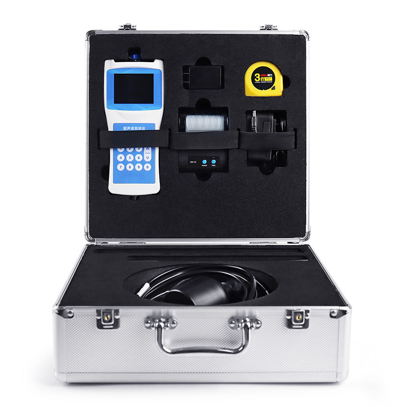
Current iterations of the Boat Depth Finder feature a highly integrated, modular design. The main unit's housing is constructed from ABS engineering plastic, while the transducer and ballast tube are made of stainless steel. The standard length of the sensor cable is 10 meters, and the total weight of the unit is kept under 1.5 kilograms, facilitating easy portability and single-person operation. The device is equipped with a full-color LCD screen (Chinese interface) capable of simultaneously displaying multiple data points, including water depth, water temperature, latitude and longitude coordinates, travel speed, time, date, battery status, and Bluetooth connection status. A built-in dual-mode BeiDou/GPS positioning module enables real-time tracking of the measurement location and ground speed, providing precise spatial reference information for hydrological surveys.
Regarding data storage and transmission, Boat Depth Finder features 16MB of built-in FLASH memory utilizing the FAT32 file system; measurement data is automatically saved in CSV format, with a storage capacity of up to 10,000 records. Users can directly access and retrieve data by connecting the device to a computer via a USB cable, or print measurement results on-site by connecting to a printer via Bluetooth. Additionally, the device is equipped with an RS485 data output interface, enabling long-distance data communication with a host computer or upper-level system.
Boat Depth Finder is capable of measuring depth in static water and can also operate stably in dynamic water environments with flow velocities not exceeding 5 meters per second. The measurement range typically spans from 0 to 150 meters, with a blanking distance of less than 0.5 meters. The measurement accuracy is ±0.5% of the full scale, and the minimum display resolution reaches 0.1 millimeters. The operating frequency automatically adjusts between 200 and 2000 kHz to accommodate measurement requirements under varying water quality conditions. The instrument operates within a temperature range of -40°C to 70°C; it is powered by a built-in rechargeable lithium battery, and its power consumption in operational mode is less than 0.3 W. This device is widely utilized in applications such as hydrological surveys, reservoir water level monitoring, river cross-section measurements, waterway dredging, and the rapid mapping of water depths during emergency rescue operations.
The rainfall monitoring station is small in size, easy to install and maintain, and inexpensive. It is very suitable for mountain flood early warning, hydrological forecasting and other work. It realizes real-time collection, remote transmission and online monitoring of rainfall data through hardwar...
Hydrological telemetry terminal is a dedicated RTU device for water management, integrating data acquisition, edge computing, and multi-protocol communication. It connects various sensors to automatically collect, process, store, and remotely transmit hydrological data such as water level, flow rate, and rainfall. It is widely used in hydrological monitoring, flood warning, and water resource management....
GNSS Monitoring Equipment employs Differential RTK technology, achieving a horizontal accuracy of ±2.5 mm + 1 ppm and a vertical accuracy of ±5 mm + 1 ppm. The device integrates a choke-ring antenna and offline processing capabilities, operating automatically in all weather conditions. It is...
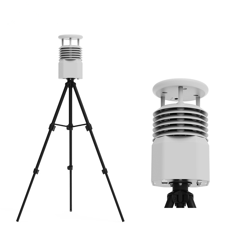
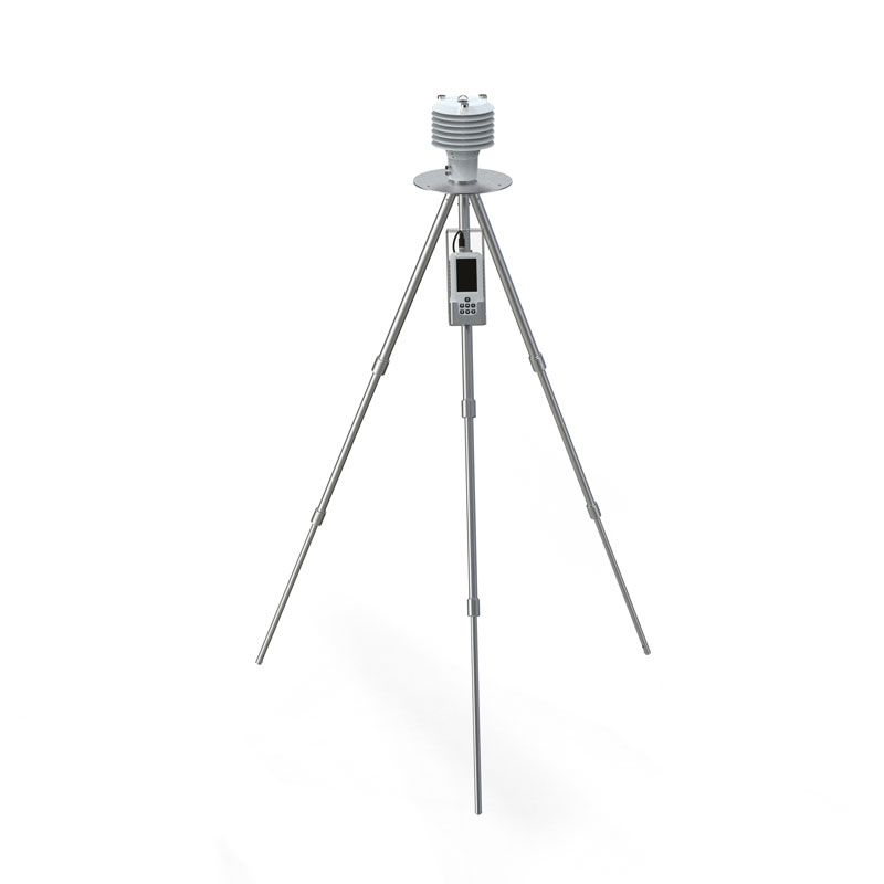
Small weather monitoring station, is an automated instrument in weather data collection, analysis and processing. It collects and stores and organizes physical quantities such as temperature and humidity in the atmosphere and then converts them into displayable graphics or text for managers to use....


 Skype
Skype
 whatsapp
 mail
mail