Shandong Fengtu IOT Technology Co., Ltd
Sales Manager:Ms. Emily Wang
Cel,Whatsapp,Wechat:+86 15898932201
Email:info@fengtutec.com
Add:No. 155 Optoelectronic Industry Accelerator, Gaoxin District, Weifang, Shandong, China


Sales Manager:Ms. Emily Wang
Cel,Whatsapp,Wechat:+86 15898932201
Email:info@fengtutec.com
Add:No. 155 Optoelectronic Industry Accelerator, Gaoxin District, Weifang, Shandong, China
time:2025-12-18 09:16:26 source:Weather Station viewed:492 time
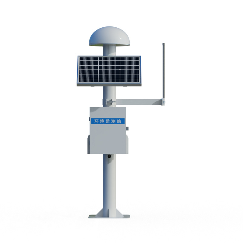
GNSS Monitoring employs differential RTK technology, using GNSS monitoring equipment to collect millimeter-level horizontal and vertical displacement data of the dam body in real time, and monitors settlement and tilt changes. This system provides continuous and accurate data for assessing the safety and stable operation of the dam structure.
GNSS Monitoring is a technical system specifically designed for continuous assessment of dam structural stability. Its core function is to monitor the deformation response of the dam body under various factors such as hydrostatic pressure, seepage, and external loads in real time through high-precision monitoring methods, providing direct data support for engineering safety management and risk early warning.
The key to achieving accurate monitoring in this system lies in the application of differential RTK technology and Global Navigation Satellite System (GNSS) equipment. Differential RTK technology, through the coordinated work of the base station and monitoring station receivers, effectively eliminates common errors such as satellite orbit errors and atmospheric delays, thereby improving GNSS positioning accuracy to the millimeter level. GNSS monitoring terminals deployed on the dam surface and key parts (such as the dam crest and abutments) continuously collect three-dimensional coordinate data at high frequency. These coordinate data, after processing, are directly converted into the horizontal and vertical displacements of the dam body. Horizontal displacement data reflects potential sliding and rotation of the dam body along or across the river, while vertical displacement data corresponds to settlement or uplift. Millimeter-level monitoring accuracy can capture early, minute deformation trends, which is crucial for assessing the dam's safety status.
In addition to core displacement monitoring, a complete GNSS Monitoring system typically integrates various supporting sensors to construct a comprehensive monitoring network. Inclination sensors are used to directly measure changes in the tilt angle of the dam body or key dam sections, serving as an important supplement and verification to GNSS displacement data. Furthermore, the system may connect to piezometers for monitoring seepage pressure and strain gauges for measuring internal deformation. Multi-source monitoring data converges to a unified data acquisition unit and is transmitted via wired or wireless communication networks to the data management platform at the safety monitoring center.
At the monitoring center, a specialized software platform is responsible for receiving, storing, and managing all real-time data. The platform has data visualization capabilities, generating charts such as displacement-time curves and settlement distribution maps, clearly demonstrating the development process of dam deformation. More importantly, the system incorporates a built-in data analysis and early warning module. This module can set multi-level early warning thresholds based on historical data and engineering safety standards. Once real-time monitoring data indicates that the displacement, settlement, or tilt rate exceeds the allowable range, or the cumulative amount approaches the design limit, the system will automatically trigger an early warning, notifying engineering management personnel via SMS, platform alarms, etc., prompting them to conduct on-site verification and diagnosis, thus gaining valuable time to take necessary engineering intervention measures.
Therefore, GNSS Monitoring is an indispensable technical infrastructure in the safety management of modern hydraulic structures. Its millimeter-level real-time displacement monitoring achieved through differential RTK-GNSS technology, combined with multi-parameter data fusion and intelligent early warning, transforms dam safety management from the traditional manual periodic inspection mode to a digital, automated, and real-time proactive monitoring mode, significantly improving the risk prevention and control capabilities and safety management level of large-scale water conservancy projects.
When choosing an anemometer, there are a few key factors to consider to decide on the best device for your needs:1. Measurement needs: If you need precise data, choose a certified anemometer; if it is just for general observation, a simple anemometer will suffice.2. Environmental suitability: If you...
Strawberries are fruits in spring, but with the development of greenhouse technology, we can now also eat strawberries in winter. Winter strawberries are harvested from greenhouses because they have meteorological requirements. Therefore, we can create an environment suitable for strawberry growth i...
accurate weather station provides accurate weather measurement results and can accurately measure a variety of meteorological elements....
the best anemometers in the world is a handheld and portable anemometer used to accurately measure wind speed....


 Skype
Skype
 whatsapp
 mail
mail