Shandong Fengtu IOT Technology Co., Ltd
Sales Manager:Ms. Emily Wang
Cel,Whatsapp,Wechat:+86 15898932201
Email:info@fengtutec.com
Add:No. 155 Optoelectronic Industry Accelerator, Gaoxin District, Weifang, Shandong, China


Sales Manager:Ms. Emily Wang
Cel,Whatsapp,Wechat:+86 15898932201
Email:info@fengtutec.com
Add:No. 155 Optoelectronic Industry Accelerator, Gaoxin District, Weifang, Shandong, China
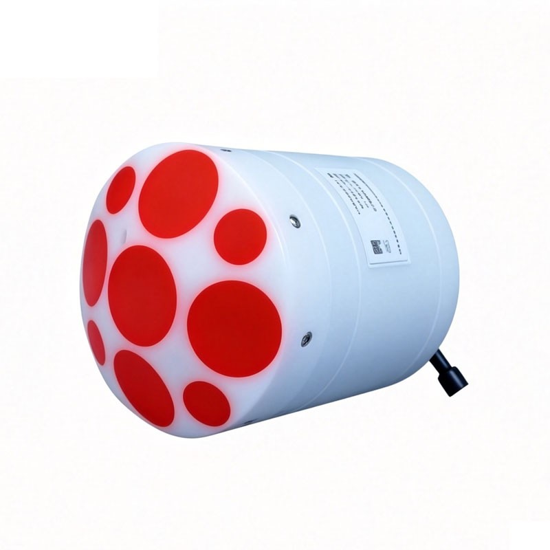
Model:ADCP-1+
Brand:fengtu
River ADCP Product introduction and technical parameters:
River ADCP is a high-precision hydrological monitoring device that uses the acoustic Doppler principle to measure river velocity profiles and flow rates. It can monitor the profile velocity, flow direction, and depth of a river.
| Composition | Technical Specifications | Parameters |
| Flow rate measurement | Operation Mode | Direct reading |
| Profile scope | 0.06-40m | |
| Flow measurement accuracy (typical) | ±0.25%±2mm/s | |
| Flow rate resolution | 1mm/s | |
| Speed test range | ±20.0m/s | |
| Flow measurement range | 0-360° | |
| Flow measurement accuracy | ±2° | |
| Number of units | 1-255 | |
| Unit layer thickness | 0.02-4m | |
| Transducer | Beam count | 9 transducers; dual 4-beam 3.0MHz/1.0MHz Janus; 1 0.5MHz vertical beam echo sounder |
| Beam angle | 25° | |
| Deep measurement | Height measurement resolution | 0.001m |
| Height measurement accuracy | 1% (full water column speed of sound corrected to 0.02%) | |
| Height measurement range | 0.2-80m | |
| Flow measurement | Bottom tracking range | 0.3-40m |
| GNSS/GPS Range | 0.3-80m, extrapolation for over 40m | |
| Internal storage | 64GB | |
| Water depth terrain measurement | Scope | 40m (slant beam) - 80m (vertical beam) |
| Velocity profile measurement range | ±10.0m/s | |
| Communication | Communication Interface | RS-232 or RS-422 |
| GNSS/GPS Communication | RS-232 Serial Input | |
| Maximum data refresh rate (output rate) | 2Hz | |
| Internal sampling rate | Maximum 70Hz | |
| Sensor | Temperature sensor | Accuracy: ±0.1℃; Resolution: 0.01℃ |
| Pressure sensor | Range: Determined by the depth rating; Accuracy: ±0.25%; Resolution: 1mm | |
| Attitude compass sensor | Range: Heading 0-360°; Accuracy (RMS): Roll ±1° | Pitch ±1° | Heading 0.8°; Resolution: 0.01° | |
| Power supply | Power supply interface | 10-26V |
| Structure | Casing material | POM |
| Environment | Operating temperature | -5℃-45℃ |
| Storage temperature | -40℃-70℃ | |
| Physical properties | Pressure depth | 50m |
| Weight (in air) | ≤1.5kg | |
| Size | Φ128mm×168mm | |
| Optional | Available options | - |
What is the main function of hydrological monitoring instruments and equipment? How do they play a role in hydrological monitoring? Next, I will make a brief introduction to these issues.The main functions of hydrological monitoring equipment are1. provide hydro-meteorological information services:...
A soil moisture monitoring system is a set of equipment used to continuously detect soil moisture, which is helpful for farmers to grow their crops. This system measures soil moisture conditions by placing sensors at different depths as needed. It also measures soil temperature and other soil proper...
Radar level meters are widely used as liquid level measurement instruments, especially in many storage tanks, where they are used for level measurement. The radar level meter emits an invisible microwave pulse, which is then converted by internal components into a digital signal and displays an accu...
Slope Stability Radar integrates multiple sensors, including slope radar, to achieve 24-hour automated monitoring of geological disasters such as landslides, collapses, and debris flows. The system boasts sub-millimeter deformation measurement accuracy and intelligent early warning capabilitie...


 Get a Free Quote
 Skype
Skype
 whatsapp
 mail
mail