Shandong Fengtu IOT Technology Co., Ltd
Sales Manager:Ms. Emily Wang
Cel,Whatsapp,Wechat:+86 15898932201
Email:info@fengtutec.com
Add:No. 155 Optoelectronic Industry Accelerator, Gaoxin District, Weifang, Shandong, China


Sales Manager:Ms. Emily Wang
Cel,Whatsapp,Wechat:+86 15898932201
Email:info@fengtutec.com
Add:No. 155 Optoelectronic Industry Accelerator, Gaoxin District, Weifang, Shandong, China
time:2026-04-30 09:36:46 source:Weather Station viewed:211 time
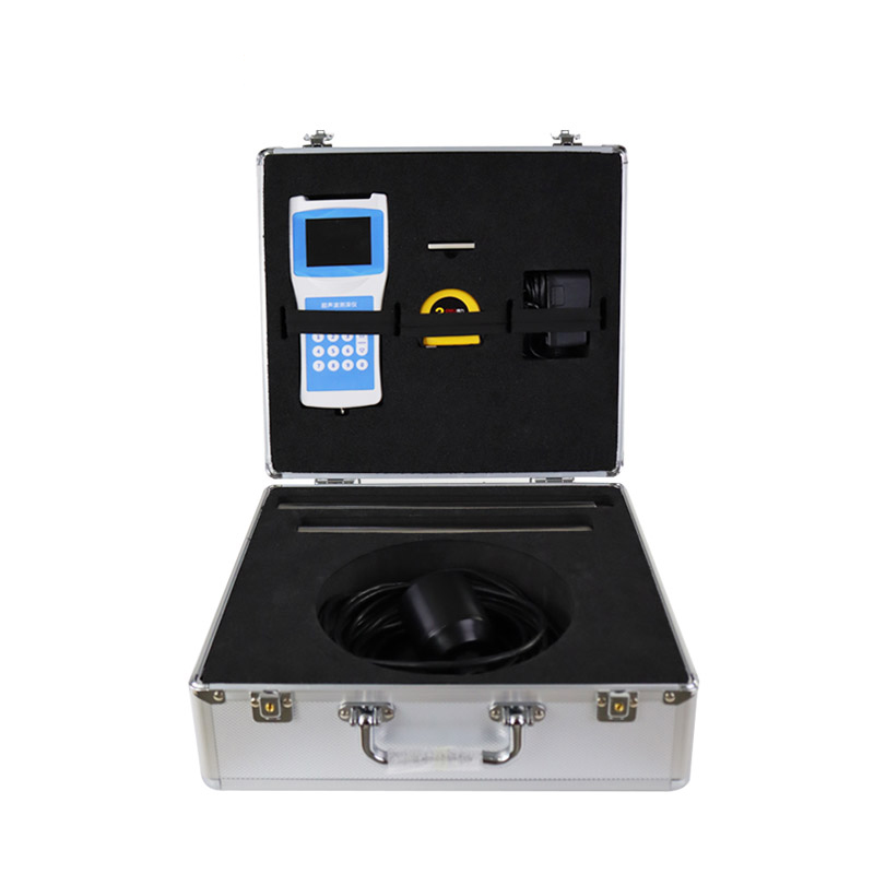
Handheld Depth Finder is a handheld ultrasonic depth-sounding device capable of simultaneously monitoring both water depth and temperature; it is suitable for measurement operations in reservoirs, lakes, rivers, and shallow coastal waters.
Handheld Depth Finder is a portable hydrological monitoring instrument designed for underwater detection, capable of simultaneously measuring two key parameters: water depth and water temperature. The device leverages the propagation characteristics of ultrasonic waves in water; by positioning an ultrasonic transducer at or just below the water surface, it emits high-frequency acoustic pulses and receives the signals reflected from the bottom. Based on the known speed of sound propagation in water and the time interval between signal transmission and reception, the device automatically calculates the water depth. Water temperature data is simultaneously collected and output in real-time by the device's built-in platinum resistance temperature sensor or thermistor module.
In terms of technical specifications, the Handheld Depth Finder features a measurement range spanning from 0 to 80 meters, a blanking distance (dead zone) of 0.5 meters, and a minimum display resolution of 0.1 millimeters, with measurement accuracy maintained within ±1% of the full range. Its transmission power supports 32 levels of automatic gain adjustment, allowing the device to automatically regulate signal output intensity based on water depth and echo strength. The device is equipped with a full-color LCD screen (Chinese interface), where measurement results—including both water depth and temperature—are intuitively displayed on dedicated data panels using both numerical and graphical formats. Operating at a frequency range of 200 to 2000 kHz, the ultrasonic transducer features an 8-degree beam angle, enabling it to effectively identify and map changes in underwater topography.
Handheld Depth Finder is suitable for use in a wide variety of aquatic environments, including reservoirs, lakes, rivers, and shallow coastal areas. In static water conditions, the ultrasonic transducer can be securely mounted either outboard or inboard on small to medium-sized vessels; utilizing self-stabilizing measurement technology and rapid tracking algorithms, the device provides accurate, real-time water depth readings. The device also operates stably in dynamic water flow environments, maintaining normal measurement functionality even in currents reaching speeds of up to 5 meters per second. Featuring a large-capacity built-in FLASH storage chip, the device automatically saves measurement data in universal file formats such as Excel and CSV. Users can export historical measurement records via a USB drive or cable to a computer for subsequent data analysis and comparative trend analysis of water depths. The Handheld Depth Finder also features a water temperature compensation function; the system automatically adjusts the propagation speed of ultrasonic waves within the water column—based on real-time temperature readings—thereby minimizing measurement errors caused by temperature fluctuations. This ensures that the instrument maintains high measurement accuracy, even in bodies of water characterized by significant seasonal temperature variations or pronounced temperature fluctuations in upstream inflows. The unit features a lightweight ABS engineering plastic housing and a compact sensor design, making it easy to handle and operate manually. When paired with a stainless steel probe rod, it is suitable for a diverse range of operational environments—from narrow groundwater wells to expansive reservoirs and lakes—establishing it as a standard field measurement tool for hydrological surveys, river channel inspections, and reservoir management.
Soil is a key natural resource and is vital for crop growth. Crops are affected by dry or excessively wet soils, and economic and social development and climate change have exacerbated the problem of drought, leading to increased water scarcity and associated disaster losses. In hilly and forested a...
Automatic water quality monitoring is of great significance for freshwater resource management. Its monitoring parameters include physical parameters (such as temperature, pH value, turbidity) and chemical parameters (such as dissolved oxygen, residual chlorine). Temperature reflects the hydrotherma...
description of a rain gauge is an instrument used by meteorologists and hydrologists to collect and measure the amount of liquid precipitation in a predetermined area, capable of measuring rainfall over a period of time....
The pH value of water is a critical indicator for measuring the acidity and alkalinity of water bodies, ranging from 0 to 14. A pH of 7 is neutral, below 7 is acidic, and above 7 is alkaline. In natural water bodies, pH affects the survival and reproduction of aquatic organisms. For example, fish ty...


 Skype
Skype
 whatsapp
 mail
mail