Shandong Fengtu IOT Technology Co., Ltd
Sales Manager:Ms. Emily Wang
Cel,Whatsapp,Wechat:+86 15898932201
Email:info@fengtutec.com
Add:No. 155 Optoelectronic Industry Accelerator, Gaoxin District, Weifang, Shandong, China


Sales Manager:Ms. Emily Wang
Cel,Whatsapp,Wechat:+86 15898932201
Email:info@fengtutec.com
Add:No. 155 Optoelectronic Industry Accelerator, Gaoxin District, Weifang, Shandong, China
time:2026-06-12 11:16:17 source:Weather Station viewed:99 time
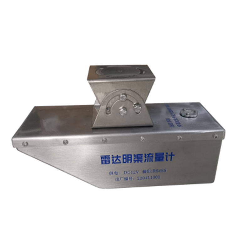
This meter employs a K-band planar microstrip array antenna, integrating vertical angle compensation and flow velocity averaging functions. It achieves a velocity measurement range of 0.1-20 m/s with an accuracy of ±0.01 m/s, and a water level measurement range of 0-30 meters. It is suitable for non-contact hydrological monitoring in rivers, irrigation canals, and flood control early warning systems.
The radar-water level and flow velocity integrated meter is a hydrological monitoring device that integrates radar water level measurement and radar flow velocity measurement. It simultaneously acquires water level and flow velocity data through non-contact measurement and calculates cross-sectional flow rate based on a built-in algorithm. The core technology of this device utilizes a K-band planar microstrip array antenna with a radar frequency of 24 GHz, featuring concentrated energy and low power consumption. The combination of K-band planar radar technology and frequency-modulated continuous wave ranging functionality enables precise measurement of water level and flow velocity. The equipment integrates multiple functional modules, including vertical angle compensation, flow velocity averaging, signal strength detection, and serial communication control. This non-contact radar flow measurement system is unaffected by sewage corrosion and siltation during velocity measurement, requires less civil construction, is less susceptible to water damage, facilitates later maintenance, and ensures the safety of on-site personnel. It is suitable not only for routine environmental monitoring but also for urgent, challenging, and dangerous observation tasks.
Regarding the measurement range of the radar-water level-flow-velocity integrated unit, the flow velocity measurement range is 0.1-20 m/s, and the liquid level measurement range is 0-30 m. The velocity measurement accuracy reaches ±0.01 m/s, meeting the comprehensive accuracy requirement of ±1%FS. The equipment supports bidirectional automatic flow velocity identification, has reverse connection protection and overvoltage protection functions, and has low system power consumption; solar power is generally sufficient for daily flow measurement needs. The equipment is equipped with an RS485 digital interface and optional 4-20 mA analog output, compatible with the standard Modbus-RTU protocol, facilitating integration with existing hydrological monitoring systems, and an optional wireless data transmission module is available. The equipment casing is made of stainless steel and aluminum alloy, achieving an IP68 protection rating. Its operating temperature range is -35℃ to 70℃, enabling long-term operation in harsh outdoor environments.
This integrated radar level and flow velocity meter can be widely used in hydrological monitoring applications such as open channels, rivers, irrigation canals, underground drainage networks, and flood control early warning systems. It can perform non-contact level and flow velocity measurements in rivers, lakes, tidal flats, reservoir gates, underground waterways, and irrigation channels. In auxiliary water treatment operations, this equipment can be used for non-contact flow measurement tasks such as urban water supply, sewage monitoring, flow calculation, and inflow/outflow monitoring. The installation of radar water level and flow velocity integrated meter is relatively simple. It can be erected using existing building foundations such as bridges or supports. However, it is necessary to ensure that the radar wave emission direction is parallel to the water flow direction. The factory default angle between the emitted wave and the water surface is 45 degrees. The installation location should be selected in a straight channel section with stable flow, avoiding proximity to gate outlets or channel bends. It is recommended to control the installation height within 5 meters to obtain a strong measurement signal and reliable data results.
In the Internet era, soil moisture monitoring systems can be revitalized by combining with technologies such as the Internet of Things, big data and artificial intelligence. For example, real-time monitoring and remote transmission of soil moisture data can be realized by using IoT technology. By de...
GNSS Monitoring Station is a product based on differential RTK technology. It is specifically designed for engineering fields such as dam safety monitoring, bridge health inspection, and landslide warning, possessing millimeter-level high-precision displacement monitoring capabilities.The power supp...
Forest weather station to monitor changes in the forest meteorological environment, forest fires is the most harmful, the most difficult to control one of the meteorological disasters, forest fires can not only damage the green plants in the forest, but also destroy the ecosystems therein, reduce th...
gas sensor detects a specific gas and measures its content in the air. A gas sensor is a device that detects the presence or concentration of a gas in the atmosphere....


 Skype
Skype
 whatsapp
 mail
mail