Shandong Fengtu IOT Technology Co., Ltd
Sales Manager:Ms. Emily Wang
Cel,Whatsapp,Wechat:+86 15898932201
Email:info@fengtutec.com
Add:No. 155 Optoelectronic Industry Accelerator, Gaoxin District, Weifang, Shandong, China


Sales Manager:Ms. Emily Wang
Cel,Whatsapp,Wechat:+86 15898932201
Email:info@fengtutec.com
Add:No. 155 Optoelectronic Industry Accelerator, Gaoxin District, Weifang, Shandong, China
time:2026-06-22 09:14:06 source:Weather Station viewed:3 time
The integrated rainfall and water level monitoring station employs K-band planar radar technology to simultaneously measure water level and rainfall in a non-contact manner. Unaffected by temperature, sediment, pollutants, or floating debris, it is suitable for scenarios such as rivers, irrigation canals, underground drainage networks, and flood warning systems. It features low power consumption and a compact size.
The integrated rainfall and water level monitoring station is a fully automated online hydrological monitoring system based on microwave technology, capable of simultaneously measuring water level and rainfall in channels. The system uses K-band planar radar technology to measure water level and rainfall in a non-contact manner, with built-in software algorithms calculating and outputting real-time data. Unlike traditional contact-based measuring equipment, the application of radar technology makes the measurement process unaffected by factors such as temperature, sediment, river pollutants, and floating debris. This characteristic makes the integrated rainfall and water level monitoring station particularly suitable for hydrological monitoring environments with high sediment content, complex water quality, or a large amount of floating debris.
In terms of application scenarios, the integrated rainfall and water level monitoring station can be used in rivers, irrigation canals, underground drainage networks, and flood warning systems. Water level and rainfall measurement in rivers, lakes, and reservoir sluice gates are the primary applications, while also assisting in urban water supply and sewage monitoring. In flood prevention and early warning, the system can monitor water level and rainfall changes in real time, providing data support for disaster prevention. For irrigation canals and underground drainage networks, the equipment helps managers understand water flow dynamics and optimize scheduling plans.
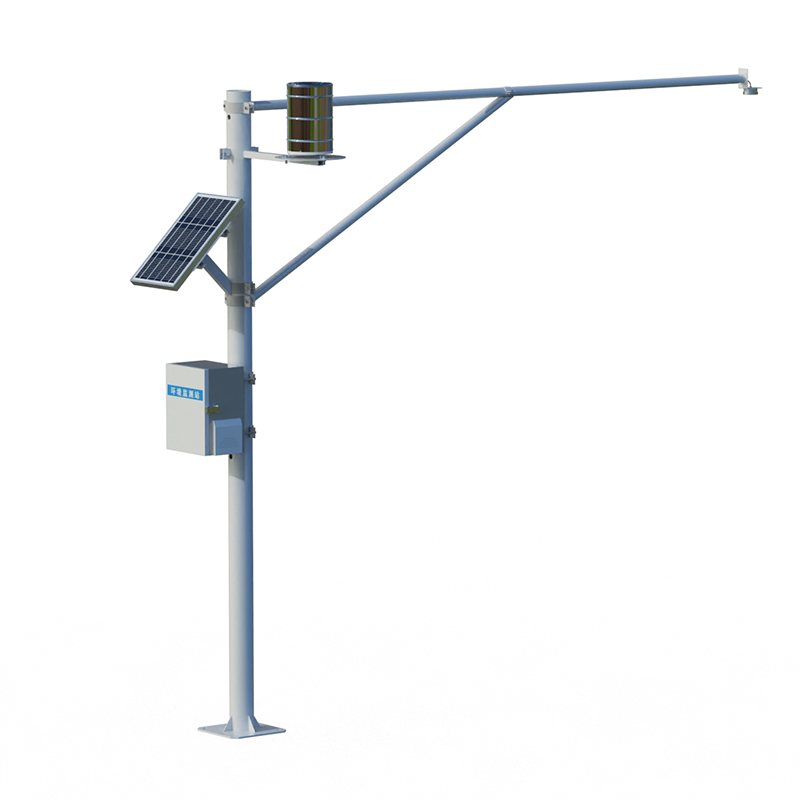
The integrated rain and water level monitoring station features low power consumption, compact size, high reliability, and easy maintenance. Its low-power design makes it suitable for long-term unattended operation in the field. Water level measurement uses a planar array radar antenna with built-in angle measurement capabilities, facilitating installation. The equipment enclosure has an IP68 protection rating and can operate stably within a temperature range of -35℃ to 60℃. Power supply options include a combination of solar panels and batteries to adapt to different installation site power conditions.
For data management, the integrated rain and water level monitoring station is typically equipped with a client-server (CS) architecture monitoring platform, allowing direct data viewing on mobile phones and PCs without the need for additional software installation. The platform features real-time data display, historical data query, data curve analysis, and threshold alarm functions. Data can be transmitted to the cloud platform via GPRS, 4G, or BeiDou satellite communication methods for remote monitoring. Some devices also integrate AI algorithms, enabling models to be trained based on historical data for water level and rainfall prediction and flood warning.
Water resources departments across the country are accelerating the deployment of integrated rain gauge and water level stations. The Ankang Municipal Water Resources Bureau has added and updated 130 automatic rain gauge and water level stations. Huyi District in Shaanxi Province has procured and constructed 7 new multi-channel integrated rain gauge and water level stations. The Shaanxi Province 2025 Mountain Flood Disaster Prevention Project plans to rebuild 6 automatic water level and rain gauge stations. With the advancement of water resources informatization, the role of integrated rain gauge and water level stations in the hydrological monitoring network will be further enhanced.
The Underground Drainage Network Collection System launched by Fengtu can accurately identify water quality issues in drainage pipe networks, and it is an important tool for promoting the transformation of urban rainwater and sewage separation, and alleviating the pressure of urban water pollution.S...
Online oil cleanliness tester employs the optical obscuration counting principle and a high-precision laser sensor to measure the size and quantity distribution of particles in oil in real time. The detection range covers 1–100 μm or 4–70 μm, and it incorporates ISO4406 and NAS1638 contami...
Crops cannot grow without the nourishment of the soil, so while exploring weather changes, it is equally crucial to have a good grasp of soil conditions. In order to achieve high quality and high yield of crops, planting must be arranged according to the characteristics and conditions of the land. S...
A wind speed and direction sensor is a device used to measure and record wind speed and direction information, which is widely used in meteorology, aviation, marine, agriculture and other fields. In these fields, accurate wind speed and direction information is of great significance for forecasting...


 Skype
Skype
 whatsapp
 mail
mail